Agnetz geodata
Agnetz (Hauts-de-France) is a populated place; located in France in Europe/Paris (GMT+2) time zone. With population of 2,840 people, there are 3433 cities with bigger population in this country. Compared to other cities in France, 87.6% of cities are located further ↓South; 51.3% of cities are located further →East and 67.4% of cities have higher elevation than Agnetz. Note1
Administrative division(s):
- Level 1: Hauts-de-France
- Level 2: Département de l'Oise
- Level 3: Arrondissement de Clermont
- Level 4: Agnetz


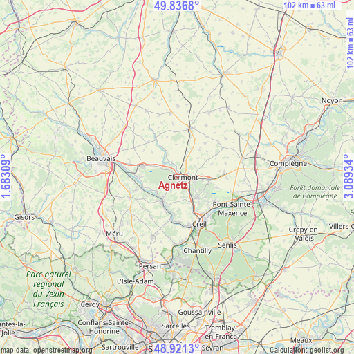
Agnetz GPS coordinates[2]
49° 22' 52.248" North, 2° 23' 10.356" East
| Map corner | latitude | longitude |
|---|---|---|
| Upper-left | 49.8368°, | 1.68309° |
| Center: | 49.38118°, | 2.38621° |
| Lower-right: | 48.9213°, | 3.08934° |
| Map W x H: | 101.8×101.8 km | = 63.3×63.3mi |
| max Lat: | 51.07786° ⇑12.4% North |
| Agnetz: | 49.38118° |
| min Lat: | ⇓87.6% South 41.3874° |
| min Long | Agnetz | max Long |
| -5.08615° | 2.38621° | 9.52242° |
| W 48.7%⇐ | ⇒51.3% E |
Elevation
Elevation of Agnetz is 84 m = 276 ft, and this is 109.7 m = 360 ft below average elevation for this country.
| Max E: |
2333 m = 7654 ft | 67.4% |
| Avg. | 193.7 m = 635 ft | |
| Agnetz | 84 m = 276 ft | |
Min E: |
-1 m = -3 ft | 32.6% |
See also: France elevation on elevation.city.
Geographical zone
Agnetz is located in North temperate zone (between Tropic of Cancer and the Arctic Circle). Distance of this North polar circle is 1910.5 km =1187.1 mi to North.| Distance of | km | miles | from Agnetz |
|---|---|---|---|
| North Pole | 4516.4 | 2806.4 | to North |
| Arctic Circle | 1910.5 | 1187.1 | to North |
| Tropic Cancer | 2884.8 | 1792.5 | to South |
| Equator | 5490.7 | 3411.8 | to South |


Nearby cities:
15 places around Agnetz: (largest is in red/bold)
• Airion
5.4 km =3.4 mi,  24°
24°
• Angy
7.1 km =4.4 mi,  216°
216°
• Bailleval
6.4 km =4 mi,  127°
127°
• Breuil-le-Sec
4.8 km =3 mi,  103°
103°
• Breuil-le-Vert
4.2 km =2.6 mi,  120°
120°
• Cambronne-lès-Clermont
5.7 km =3.5 mi,  170°
170°
• Clermont
1.9 km =1.2 mi, 97°
• Erquery
6 km =3.7 mi,  59°
59°
• Fitz-James
3.4 km =2.1 mi,  71°
71°
• La Neuville-en-Hez
5 km =3.1 mi,  299°
299°
• La Rue-Saint-Pierre
7.3 km =4.5 mi, 295°
• Neuilly-sous-Clermont
4.4 km =2.7 mi,  156°
156°
• Rantigny
7.2 km =4.5 mi,  145°
145°
• Thury-sous-Clermont
4.9 km =3 mi,  237°
237°
• Étouy
4.5 km =2.8 mi,  338°
338°
Sources, notices
• [Note1] Compared only with cities in France existing in our database
• [Src1] Map data: © OpenStreetMap contributors (CC-BY-SA)
• [Src2] Other city data from geonames.org with taken over terms of usage.
• [Src3] Geographical zone / Annual Mean Temperature by Robert A. Rohde @ Wikipedia
