La Neuville-en-Hez geodata
La Neuville-en-Hez (Hauts-de-France) is a populated place; located in France in Europe/Paris (GMT+2) time zone. With population of 944 people, there are 9259 cities with bigger population in this country. Compared to other cities in France, 88% of cities are located further ↓South; 52.3% of cities are located further →East and 76.2% of cities have higher elevation than La Neuville-en-Hez. Note1
Administrative division(s):
- Level 1: Hauts-de-France
- Level 2: Département de l'Oise
- Level 3: Arrondissement de Clermont
- Level 4: La Neuville-en-Hez


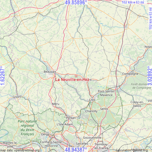
La Neuville-en-Hez GPS coordinates[2]
49° 24' 12.78" North, 2° 19' 32.844" East
| Map corner | latitude | longitude |
|---|---|---|
| Upper-left | 49.85896°, | 1.62267° |
| Center: | 49.40355°, | 2.32579° |
| Lower-right: | 48.94387°, | 3.02892° |
| Map W x H: | 101.7×101.7 km | = 63.2×63.2mi |
| max Lat: | 51.07786° ⇑12% North |
| La Neuville-en-Hez: | 49.40355° |
| min Lat: | ⇓88% South 41.3874° |
| min Long | La Neuville-en- | max Long |
| -5.08615° | 2.32579° | 9.52242° |
| W 47.7%⇐ | ⇒52.3% E |
Elevation
Elevation of La Neuville-en-Hez is 64 m = 210 ft, and this is 129.7 m = 426 ft below average elevation for this country.
| Max E: |
2333 m = 7654 ft | 76.2% |
| Avg. | 193.7 m = 635 ft | |
| La Neuville-en-Hez | 64 m = 210 ft | |
Min E: |
-1 m = -3 ft | 23.8% |
See also: France elevation on elevation.city.
Geographical zone
La Neuville-en-Hez is located in North temperate zone (between Tropic of Cancer and the Arctic Circle). Distance of this North polar circle is 1908 km =1185.6 mi to North.| Distance of | km | miles | from La Neuville-en-Hez |
|---|---|---|---|
| North Pole | 4513.9 | 2804.8 | to North |
| Arctic Circle | 1908 | 1185.6 | to North |
| Tropic Cancer | 2887.2 | 1794 | to South |
| Equator | 5493.2 | 3413.3 | to South |


Nearby cities:
15 places around La Neuville-en-Hez: (largest is in red/bold)
• Agnetz
5 km =3.1 mi,  119°
119°
• Airion
7 km =4.3 mi,  69°
69°
• Angy
8.2 km =5.1 mi,  178°
178°
• Bailleul-sur-Thérain
7.7 km =4.8 mi,  254°
254°
• Bresles
5.5 km =3.4 mi,  277°
277°
• Bulles
6.2 km =3.9 mi,  359°
359°
• Clermont
6.9 km =4.3 mi,  113°
113°
• Fitz-James
7.7 km =4.8 mi,  100°
100°
• Fournival
8.2 km =5.1 mi,  30°
30°
• Hermes
7.6 km =4.7 mi,  230°
230°
• Hondainville
7.2 km =4.5 mi,  193°
193°
• La Rue-Saint-Pierre
2.3 km =1.4 mi,  287°
287°
• Saint-Félix
5.9 km =3.7 mi,  211°
211°
• Thury-sous-Clermont
5.1 km =3.2 mi, 177°
• Étouy
3.2 km =2 mi,  58°
58°
Sources, notices
• [Note1] Compared only with cities in France existing in our database
• [Src1] Map data: © OpenStreetMap contributors (CC-BY-SA)
• [Src2] Other city data from geonames.org with taken over terms of usage.
• [Src3] Geographical zone / Annual Mean Temperature by Robert A. Rohde @ Wikipedia
