Saint-Armel geodata
Saint-Armel (Brittany) is a populated place; located in France in Europe/Paris (GMT+2) time zone. With population of 789 people, there are 10726 cities with bigger population in this country. Compared to other cities in France, 52.3% of cities are located further ↓South; 96.7% of cities are located further →East and 97.8% of cities have higher elevation than Saint-Armel. Note1
Administrative division(s):
- Level 1: Brittany
- Level 2: Morbihan
- Level 3: Arrondissement de Vannes
- Level 4: Saint-Armel


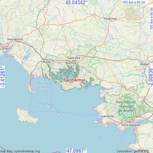
Saint-Armel GPS coordinates[2]
47° 34' 23.556" North, 2° 42' 34.164" West
| Map corner | latitude | longitude |
|---|---|---|
| Upper-left | 48.04542°, | -3.41261° |
| Center: | 47.57321°, | -2.70949° |
| Lower-right: | 47.0967°, | -2.00636° |
| Map W x H: | 105.5×105.5 km | = 65.6×65.6mi |
| max Lat: | 51.07786° ⇑47.7% North |
| Saint-Armel: | 47.57321° |
| min Lat: | ⇓52.3% South 41.3874° |
| min Long | Saint-Armel | max Long |
| -5.08615° | -2.70949° | 9.52242° |
| W 3.3%⇐ | ⇒96.7% E |
Elevation
Elevation of Saint-Armel is 9 m = 30 ft, and this is 184.7 m = 606 ft below average elevation for this country.
| Max E: |
2333 m = 7654 ft | 97.8% |
| Avg. | 193.7 m = 635 ft | |
| Saint-Armel | 9 m = 30 ft | |
Min E: |
-1 m = -3 ft | 2.2% |
See also: France elevation on elevation.city.
Geographical zone
Saint-Armel is located in North temperate zone (between Tropic of Cancer and the Arctic Circle). Distance of this North polar circle is 2111.5 km =1312 mi to North.| Distance of | km | miles | from Saint-Armel |
|---|---|---|---|
| North Pole | 4717.4 | 2931.3 | to North |
| Arctic Circle | 2111.5 | 1312 | to North |
| Tropic Cancer | 2683.7 | 1667.6 | to South |
| Equator | 5289.6 | 3286.8 | to South |


Nearby cities:
15 places around Saint-Armel: (largest is in red/bold)
• Ambon
11.8 km =7.3 mi,  100°
100°
• Arradon
10.3 km =6.4 mi,  305°
305°
• Damgan
11.7 km =7.3 mi,  121°
121°
• La Trinité-Surzur
9.4 km =5.8 mi,  68°
68°
• Lauzach
13.2 km =8.2 mi, 69°
• Le Hézo
1.5 km =0.9 mi,  22°
22°
• Le Tour-du-Parc
7.2 km =4.5 mi,  138°
138°
• Noyalo
4.7 km =2.9 mi,  30°
30°
• Saint-Gildas-de-Rhuys
12.6 km =7.8 mi,  230°
230°
• Sarzeau
6.8 km =4.2 mi,  221°
221°
• Surzur
6.1 km =3.8 mi,  84°
84°
• Séné
5.5 km =3.4 mi,  337°
337°
• Theix
7.6 km =4.7 mi, 34°
• Vannes
10 km =6.2 mi, 339°
• Île-aux-Moines
10.4 km =6.5 mi,  284°
284°
Sources, notices
• [Note1] Compared only with cities in France existing in our database
• [Src1] Map data: © OpenStreetMap contributors (CC-BY-SA)
• [Src2] Other city data from geonames.org with taken over terms of usage.
• [Src3] Geographical zone / Annual Mean Temperature by Robert A. Rohde @ Wikipedia
