Vannes geodata
Vannes (Brittany) is a seat of a second-order administrative division; located in France in Europe/Paris (GMT+2) time zone. With population of 54,020 people, there are 100 cities with bigger population in this country. Compared to other cities in France, 53.6% of cities are located further ↓South; 96.8% of cities are located further →East and 98.2% of cities have higher elevation than Vannes. Note1
Administrative division(s):
- Level 1: Brittany
- Level 2: Morbihan
- Level 3: Arrondissement de Vannes
- Level 4: Vannes


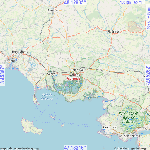
Vannes GPS coordinates[2]
47° 39' 28.44" North, 2° 45' 20.664" West
| Map corner | latitude | longitude |
|---|---|---|
| Upper-left | 48.12935°, | -3.45887° |
| Center: | 47.6579°, | -2.75574° |
| Lower-right: | 47.18216°, | -2.05262° |
| Map W x H: | 105.3×105.3 km | = 65.4×65.4mi |
| max Lat: | 51.07786° ⇑46.4% North |
| Vannes: | 47.6579° |
| min Lat: | ⇓53.6% South 41.3874° |
| min Long | Vannes | max Long |
| -5.08615° | -2.75574° | 9.52242° |
| W 3.2%⇐ | ⇒96.8% E |
Elevation
Elevation of Vannes is 8 m = 26 ft, and this is 185.7 m = 609 ft below average elevation for this country.
| Max E: |
2333 m = 7654 ft | 98.2% |
| Avg. | 193.7 m = 635 ft | |
| Vannes | 8 m = 26 ft | |
Min E: |
-1 m = -3 ft | 1.8% |
See also: Vannes elevation on elevation.city.
Geographical zone
Vannes is located in North temperate zone (between Tropic of Cancer and the Arctic Circle). Distance of this North polar circle is 2102.1 km =1306.2 mi to North.| Distance of | km | miles | from Vannes |
|---|---|---|---|
| North Pole | 4708 | 2925.4 | to North |
| Arctic Circle | 2102.1 | 1306.2 | to North |
| Tropic Cancer | 2693.1 | 1673.4 | to South |
| Equator | 5299.1 | 3292.7 | to South |


Nearby cities:
15 places around Vannes: (largest is in red/bold)
• Arradon
6 km =3.7 mi,  235°
235°
• Le Hézo
9 km =5.6 mi,  153°
153°
• Locmaria-Grand-Champ
11.2 km =7 mi,  348°
348°
• Meucon
6.5 km =4 mi,  356°
356°
• Monterblanc
11 km =6.8 mi,  31°
31°
• Noyalo
8 km =5 mi,  132°
132°
• Plescop
5.8 km =3.6 mi,  319°
319°
• Ploeren
8.1 km =5 mi,  269°
269°
• Saint-Armel
10 km =6.2 mi,  159°
159°
• Saint-Avé
3.7 km =2.3 mi,  10°
10°
• Saint-Nolff
9.3 km =5.8 mi,  56°
56°
• Séné
4.5 km =2.8 mi, 162°
• Theix
8.4 km =5.2 mi,  112°
112°
• Treffléan
11 km =6.8 mi,  76°
76°
• Île-aux-Moines
9.5 km =5.9 mi,  224°
224°
Sources, notices
• [Note1] Compared only with cities in France existing in our database
• [Src1] Map data: © OpenStreetMap contributors (CC-BY-SA)
• [Src2] Other city data from geonames.org with taken over terms of usage.
• [Src3] Geographical zone / Annual Mean Temperature by Robert A. Rohde @ Wikipedia
