Saint-Joseph geodata
Saint-Joseph (Provence-Alpes-Côte d'Azur) is a section of populated place; located in France in Europe/Paris (GMT+2) time zone. With population of 5,246 people, there are 1874 cities with bigger population in this country. Compared to other cities in France, 94.9% of cities are located further ↑North; 81.6% of cities are located further ←West and 59.4% of cities have higher elevation than Saint-Joseph. Note1
Administrative division(s):
- Level 1: Provence-Alpes-Côte d'Azur
- Level 2: Département des Bouches-du-Rhône
- Level 3: Arrondissement de Marseille
- Level 4: Marseille


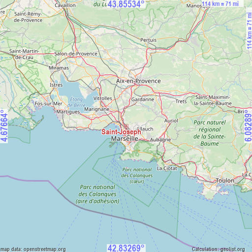
Saint-Joseph GPS coordinates[2]
43° 20' 46.212" North, 5° 22' 47.136" East
| Map corner | latitude | longitude |
|---|---|---|
| Upper-left | 43.85534°, | 4.67664° |
| Center: | 43.34617°, | 5.37976° |
| Lower-right: | 42.83269°, | 6.08289° |
| Map W x H: | 113.7×113.7 km | = 70.6×70.6mi |
| max Lat: | 51.07786° ⇑94.9% North |
| Saint-Joseph: | 43.34617° |
| min Lat: | ⇓5.1% South 41.3874° |
| min Long | Saint-Joseph | max Long |
| -5.08615° | 5.37976° | 9.52242° |
| W 81.6%⇐ | ⇒18.4% E |
Elevation
Elevation of Saint-Joseph is 104 m = 341 ft, and this is 89.7 m = 294 ft below average elevation for this country.
| Max E: |
2333 m = 7654 ft | 59.4% |
| Avg. | 193.7 m = 635 ft | |
| Saint-Joseph | 104 m = 341 ft | |
Min E: |
-1 m = -3 ft | 40.6% |
See also: France elevation on elevation.city.
Geographical zone
Saint-Joseph is located in North temperate zone (between Tropic of Cancer and the Arctic Circle). Distance of this Northern Tropic circle is 2213.7 km =1375.5 mi to South.| Distance of | km | miles | from Saint-Joseph |
|---|---|---|---|
| North Pole | 5187.4 | 3223.3 | to North |
| Arctic Circle | 2581.5 | 1604.1 | to North |
| Tropic Cancer | 2213.7 | 1375.5 | to South |
| Equator | 4819.6 | 2994.8 | to South |


Nearby cities:
15 places around Saint-Joseph: (largest is in red/bold)
• Bon-Secours
3 km =1.9 mi,  173°
173°
• Borel
2.3 km =1.4 mi,  333°
333°
• La Cabucelle
2.2 km =1.4 mi,  223°
223°
• La Calade
2.5 km =1.6 mi,  250°
250°
• La Delorme
0.6 km =0.4 mi, 248°
• La Viste
2.4 km =1.5 mi,  307°
307°
• Le Canet
2.3 km =1.4 mi,  195°
195°
• Le Merlan
2.4 km =1.5 mi,  110°
110°
• Les Arnavaux
1.2 km =0.7 mi,  180°
180°
• Les Aygalades
1.4 km =0.9 mi, 330°
• Les Crottes
2.7 km =1.7 mi, 200°
• Marseille 14
0.2 km =0.1 mi, 173°
• Saint-Barthélémy
2.5 km =1.6 mi,  132°
132°
• Saint-Louis
2 km =1.2 mi,  275°
275°
• Sainte-Marthe
1.6 km =1 mi,  144°
144°
Sources, notices
• [Note1] Compared only with cities in France existing in our database
• [Src1] Map data: © OpenStreetMap contributors (CC-BY-SA)
• [Src2] Other city data from geonames.org with taken over terms of usage.
• [Src3] Geographical zone / Annual Mean Temperature by Robert A. Rohde @ Wikipedia
