Saint-Barthélémy geodata
Saint-Barthélémy (Provence-Alpes-Côte d'Azur) is a section of populated place; located in France in Europe/Paris (GMT+2) time zone. With population of 18,655 people, there are 502 cities with bigger population in this country. Compared to other cities in France, 95.2% of cities are located further ↑North; 81.9% of cities are located further ←West and 62.8% of cities have higher elevation than Saint-Barthélémy. Note1
Administrative division(s):
- Level 1: Provence-Alpes-Côte d'Azur
- Level 2: Département des Bouches-du-Rhône
- Level 3: Arrondissement de Marseille
- Level 4: Marseille


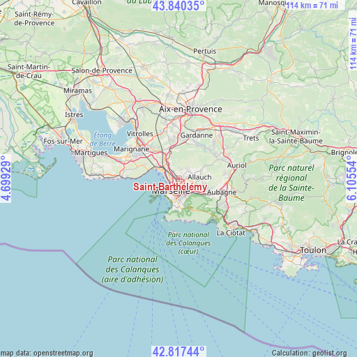
Saint-Barthélémy GPS coordinates[2]
43° 19' 51.78" North, 5° 24' 8.676" East
| Map corner | latitude | longitude |
|---|---|---|
| Upper-left | 43.84035°, | 4.69929° |
| Center: | 43.33105°, | 5.40241° |
| Lower-right: | 42.81744°, | 6.10554° |
| Map W x H: | 113.7×113.7 km | = 70.6×70.6mi |
| max Lat: | 51.07786° ⇑95.2% North |
| Saint-Barthélémy: | 43.33105° |
| min Lat: | ⇓4.8% South 41.3874° |
| min Long | Saint-Barthél� | max Long |
| -5.08615° | 5.40241° | 9.52242° |
| W 81.9%⇐ | ⇒18.1% E |
Elevation
Elevation of Saint-Barthélémy is 95 m = 312 ft, and this is 98.7 m = 324 ft below average elevation for this country.
| Max E: |
2333 m = 7654 ft | 62.8% |
| Avg. | 193.7 m = 635 ft | |
| Saint-Barthélémy | 95 m = 312 ft | |
Min E: |
-1 m = -3 ft | 37.2% |
See also: France elevation on elevation.city.
Geographical zone
Saint-Barthélémy is located in North temperate zone (between Tropic of Cancer and the Arctic Circle). Distance of this Northern Tropic circle is 2212 km =1374.5 mi to South.| Distance of | km | miles | from Saint-Barthélémy |
|---|---|---|---|
| North Pole | 5189.1 | 3224.4 | to North |
| Arctic Circle | 2583.2 | 1605.1 | to North |
| Tropic Cancer | 2212 | 1374.5 | to South |
| Equator | 4818 | 2993.8 | to South |


Nearby cities:
15 places around Saint-Barthélémy: (largest is in red/bold)
• Belle de Mai
2.5 km =1.6 mi,  212°
212°
• Bon-Secours
2 km =1.2 mi,  228°
228°
• Chutes-Lavie
2.4 km =1.5 mi,  195°
195°
• La Rose
2.1 km =1.3 mi,  96°
96°
• Le Merlan
1 km =0.6 mi,  26°
26°
• Les Arnavaux
1.9 km =1.2 mi,  283°
283°
• Les Chartreux
2.2 km =1.4 mi,  175°
175°
• Malpassé
1.5 km =0.9 mi,  134°
134°
• Marseille 13
1.5 km =0.9 mi,  160°
160°
• Marseille 14
2.3 km =1.4 mi,  309°
309°
• Montolivet
2.3 km =1.4 mi, 132°
• Saint-Just
1.6 km =1 mi,  169°
169°
• Saint-Jérôme
1.3 km =0.8 mi,  74°
74°
• Saint-Mitre
2.4 km =1.5 mi,  43°
43°
• Sainte-Marthe
1 km =0.6 mi,  292°
292°
Sources, notices
• [Note1] Compared only with cities in France existing in our database
• [Src1] Map data: © OpenStreetMap contributors (CC-BY-SA)
• [Src2] Other city data from geonames.org with taken over terms of usage.
• [Src3] Geographical zone / Annual Mean Temperature by Robert A. Rohde @ Wikipedia
