Worcester geodata
Worcester (England) is a seat of a second-order administrative division; located in United Kingdom in Europe/London (GMT+1) time zone. With population of 101,659 people, there are 95 cities with bigger population in this country. Compared to other cities in United Kingdom, 56.8% of cities are located further ↑North; 59.7% of cities are located further →East and 73.1% of cities have higher elevation than Worcester. Note1


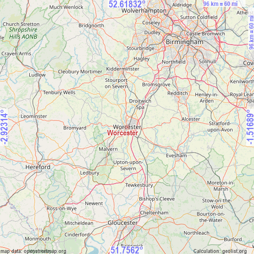
Worcester GPS coordinates[2]
52° 11' 21.66" North, 2° 13' 12.036" West
| Map corner | latitude | longitude |
|---|---|---|
| Upper-left | 52.61832°, | -2.92314° |
| Center: | 52.18935°, | -2.22001° |
| Lower-right: | 51.7562°, | -1.51689° |
| Map W x H: | 95.9×95.9 km | = 59.6×59.6mi |
| max Lat: | 60.39635° ⇑56.8% North |
| Worcester: | 52.18935° |
| min Lat: | ⇓43.2% South 34.60088° |
| min Long | Worcester | max Long |
| -7.64133° | -2.22001° | 32.95536° |
| W 40.3%⇐ | ⇒59.7% E |
Elevation
Elevation of Worcester is 29 m = 95 ft, and this is 43.9 m = 144 ft below average elevation for this country.
| Max E: |
515 m = 1690 ft | 73.1% |
| Avg. | 72.9 m = 239 ft | |
| Worcester | 29 m = 95 ft | |
Min E: |
-30 m = -98 ft | 26.9% |
See also: Worcester elevation on elevation.city.
Geographical zone
Worcester is located in North temperate zone (between Tropic of Cancer and the Arctic Circle). Distance of this North polar circle is 1598.3 km =993.1 mi to North.| Distance of | km | miles | from Worcester |
|---|---|---|---|
| North Pole | 4204.2 | 2612.4 | to North |
| Arctic Circle | 1598.3 | 993.1 | to North |
| Tropic Cancer | 3197 | 1986.5 | to South |
| Equator | 5802.9 | 3605.8 | to South |


Nearby cities:
15 places around Worcester: (largest is in red/bold)
• Bransford
5.9 km =3.7 mi,  251°
251°
• Cotheridge
6.3 km =3.9 mi,  273°
273°
• Defford
13.2 km =8.2 mi,  149°
149°
• Droitwich
9.8 km =6.1 mi,  29°
29°
• Fernhill Heath
4.8 km =3 mi,  19°
19°
• Great Malvern
11.2 km =7 mi,  219°
219°
• Hallow
4.5 km =2.8 mi,  328°
328°
• Hanley Swan
12.3 km =7.6 mi,  197°
197°
• Kempsey
5.6 km =3.5 mi,  178°
178°
• Leigh
6.7 km =4.2 mi,  257°
257°
• Lower Broadheath
4.8 km =3 mi,  304°
304°
• Ombersley
9.1 km =5.7 mi,  356°
356°
• Peopleton
9.6 km =6 mi,  114°
114°
• Pershore
13.1 km =8.1 mi,  131°
131°
• Wychbold
13.3 km =8.3 mi, 32°
Sources, notices
• [Note1] Compared only with cities in United Kingdom existing in our database
• [Src1] Map data: © OpenStreetMap contributors (CC-BY-SA)
• [Src2] Other city data from geonames.org with taken over terms of usage.
• [Src3] Geographical zone / Annual Mean Temperature by Robert A. Rohde @ Wikipedia
