Winchester geodata
Winchester (England) is a seat of a second-order administrative division; located in United Kingdom in Europe/London (GMT+0) time zone. With population of 46,074 people, there are 258 cities with bigger population in this country. Compared to other cities in United Kingdom, 90% of cities are located further ↑North; 59.7% of cities are located further ←West and 50.3% of cities have lower elevation than Winchester. Note1


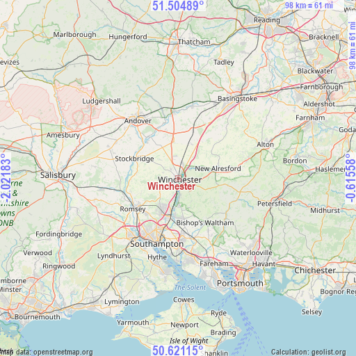
Winchester GPS coordinates[2]
51° 3' 54.468" North, 1° 19' 7.32" West
| Map corner | latitude | longitude |
|---|---|---|
| Upper-left | 51.50489°, | -2.02183° |
| Center: | 51.06513°, | -1.3187° |
| Lower-right: | 50.62115°, | -0.61558° |
| Map W x H: | 98.3×98.3 km | = 61.1×61.1mi |
| max Lat: | 60.39635° ⇑90% North |
| Winchester: | 51.06513° |
| min Lat: | ⇓10% South 34.60088° |
| min Long | Winchester | max Long |
| -7.64133° | -1.3187° | 32.95536° |
| W 59.7%⇐ | ⇒40.3% E |
Elevation
Elevation of Winchester is 61 m = 200 ft, and this is 11.9 m = 39 ft below average elevation for this country.
| Max E: |
515 m = 1690 ft | 49.7% |
| Avg. | 72.9 m = 239 ft | |
| Winchester | 61 m = 200 ft | |
Min E: |
-30 m = -98 ft | 50.3% |
See also: Winchester elevation on elevation.city.
Geographical zone
Winchester is located in North temperate zone (between Tropic of Cancer and the Arctic Circle). Distance of this North polar circle is 1723.3 km =1070.8 mi to North.| Distance of | km | miles | from Winchester |
|---|---|---|---|
| North Pole | 4329.2 | 2690 | to North |
| Arctic Circle | 1723.3 | 1070.8 | to North |
| Tropic Cancer | 3072 | 1908.9 | to South |
| Equator | 5677.9 | 3528.1 | to South |


Nearby cities:
15 places around Winchester: (largest is in red/bold)
• Barton Stacey
12 km =7.5 mi,  339°
339°
• Bishops Waltham
14.2 km =8.8 mi,  149°
149°
• Bishopstoke
11 km =6.8 mi,  183°
183°
• Chilbolton
13.3 km =8.3 mi,  321°
321°
• Colden Common
7.8 km =4.8 mi, 176°
• Compton
4.8 km =3 mi,  195°
195°
• Eastleigh
11.2 km =7 mi,  191°
191°
• Kings Worthy
3 km =1.9 mi,  29°
29°
• Michelmersh
13.5 km =8.4 mi,  254°
254°
• New Alresford
10.6 km =6.6 mi,  77°
77°
• North Baddesley
13.2 km =8.2 mi,  222°
222°
• Owslebury
7.2 km =4.5 mi, 150°
• Romsey
15.2 km =9.4 mi,  236°
236°
• Stockbridge
13 km =8.1 mi,  294°
294°
• Sutton Scotney
10 km =6.2 mi,  352°
352°
Sources, notices
• [Note1] Compared only with cities in United Kingdom existing in our database
• [Src1] Map data: © OpenStreetMap contributors (CC-BY-SA)
• [Src2] Other city data from geonames.org with taken over terms of usage.
• [Src3] Geographical zone / Annual Mean Temperature by Robert A. Rohde @ Wikipedia
