Eastleigh geodata
Eastleigh (England) is a populated place; located in United Kingdom in Europe/London (GMT+0) time zone. With population of 54,225 people, there are 213 cities with bigger population in this country. Compared to other cities in United Kingdom, 91.9% of cities are located further ↑North; 58.9% of cities are located further ←West and 91.2% of cities have higher elevation than Eastleigh. Note1


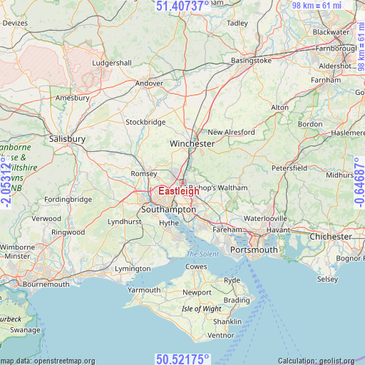
Eastleigh GPS coordinates[2]
50° 58' 0.012" North, 1° 21' 0" West
| Map corner | latitude | longitude |
|---|---|---|
| Upper-left | 51.40737°, | -2.05312° |
| Center: | 50.96667°, | -1.35° |
| Lower-right: | 50.52175°, | -0.64687° |
| Map W x H: | 98.5×98.5 km | = 61.2×61.2mi |
| max Lat: | 60.39635° ⇑91.9% North |
| Eastleigh: | 50.96667° |
| min Lat: | ⇓8.1% South 34.60088° |
| min Long | Eastleigh | max Long |
| -7.64133° | -1.35° | 32.95536° |
| W 58.9%⇐ | ⇒41.1% E |
Elevation
Elevation of Eastleigh is 11 m = 36 ft, and this is 61.9 m = 203 ft below average elevation for this country.
| Max E: |
515 m = 1690 ft | 91.2% |
| Avg. | 72.9 m = 239 ft | |
| Eastleigh | 11 m = 36 ft | |
Min E: |
-30 m = -98 ft | 8.8% |
See also: Eastleigh elevation on elevation.city.
Geographical zone
Eastleigh is located in North temperate zone (between Tropic of Cancer and the Arctic Circle). Distance of this North polar circle is 1734.2 km =1077.6 mi to North.| Distance of | km | miles | from Eastleigh |
|---|---|---|---|
| North Pole | 4340.1 | 2696.8 | to North |
| Arctic Circle | 1734.2 | 1077.6 | to North |
| Tropic Cancer | 3061 | 1902 | to South |
| Equator | 5667 | 3521.3 | to South |


Nearby cities:
15 places around Eastleigh: (largest is in red/bold)
• Bishops Waltham
9.5 km =5.9 mi,  97°
97°
• Bishopstoke
1.5 km =0.9 mi,  91°
91°
• Botley
8.1 km =5 mi,  136°
136°
• Bursledon
9.2 km =5.7 mi,  165°
165°
• Colden Common
4.1 km =2.5 mi,  40°
40°
• Compton
6.4 km =4 mi,  8°
8°
• Curdridge
8.7 km =5.4 mi,  123°
123°
• Hedge End
7 km =4.3 mi,  150°
150°
• Netley
10 km =6.2 mi,  181°
181°
• North Baddesley
6.8 km =4.2 mi,  280°
280°
• Owslebury
7.4 km =4.6 mi,  51°
51°
• Romsey
10.8 km =6.7 mi, 283°
• Southampton
7.9 km =4.9 mi,  208°
208°
• West End
4.5 km =2.8 mi,  164°
164°
• Winchester
11.2 km =7 mi, 11°
Sources, notices
• [Note1] Compared only with cities in United Kingdom existing in our database
• [Src1] Map data: © OpenStreetMap contributors (CC-BY-SA)
• [Src2] Other city data from geonames.org with taken over terms of usage.
• [Src3] Geographical zone / Annual Mean Temperature by Robert A. Rohde @ Wikipedia
