Michelmersh geodata
Michelmersh (England) is a populated place; located in United Kingdom in Europe/London (GMT+1) time zone. With population of 881 people, there are 3849 cities with bigger population in this country. Compared to other cities in United Kingdom, 90.6% of cities are located further ↑North; 55.4% of cities are located further ←West and 53% of cities have higher elevation than Michelmersh. Note1
Administrative division(s):
- Level 1: England
- Level 2: Hampshire
- Level 3: Test Valley District
- Level 4: Michelmersh and Timsbury


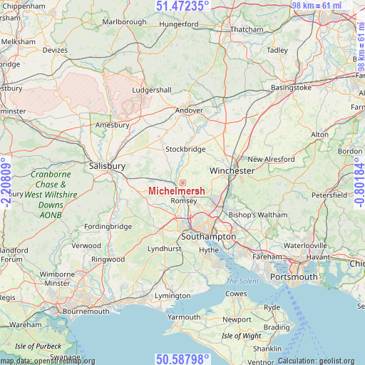
Michelmersh GPS coordinates[2]
51° 1' 56.172" North, 1° 30' 17.856" West
| Map corner | latitude | longitude |
|---|---|---|
| Upper-left | 51.47235°, | -2.20809° |
| Center: | 51.03227°, | -1.50496° |
| Lower-right: | 50.58798°, | -0.80184° |
| Map W x H: | 98.3×98.3 km | = 61.1×61.1mi |
| max Lat: | 60.39635° ⇑90.6% North |
| Michelmersh: | 51.03227° |
| min Lat: | ⇓9.4% South 34.60088° |
| min Long | Michelmersh | max Long |
| -7.64133° | -1.50496° | 32.95536° |
| W 55.4%⇐ | ⇒44.6% E |
Elevation
Elevation of Michelmersh is 56 m = 184 ft, and this is 16.9 m = 55 ft below average elevation for this country.
| Max E: |
515 m = 1690 ft | 53% |
| Avg. | 72.9 m = 239 ft | |
| Michelmersh | 56 m = 184 ft | |
Min E: |
-30 m = -98 ft | 47% |
See also: United Kingdom elevation on elevation.city.
Geographical zone
Michelmersh is located in North temperate zone (between Tropic of Cancer and the Arctic Circle). Distance of this North polar circle is 1726.9 km =1073 mi to North.| Distance of | km | miles | from Michelmersh |
|---|---|---|---|
| North Pole | 4332.8 | 2692.3 | to North |
| Arctic Circle | 1726.9 | 1073 | to North |
| Tropic Cancer | 3068.3 | 1906.6 | to South |
| Equator | 5674.3 | 3525.8 | to South |


Nearby cities:
15 places around Michelmersh: (largest is in red/bold)
• Bishopstoke
14.4 km =8.9 mi,  120°
120°
• Cadnam
13.5 km =8.4 mi,  202°
202°
• Colden Common
14.2 km =8.8 mi,  107°
107°
• Compton
11.8 km =7.3 mi,  94°
94°
• East Dean
7.4 km =4.6 mi,  276°
276°
• Eastleigh
13.1 km =8.1 mi, 123°
• Middle Winterslow
12.5 km =7.8 mi,  303°
303°
• North Baddesley
7.4 km =4.6 mi,  145°
145°
• Over Wallop
14.1 km =8.8 mi,  333°
333°
• Romsey
4.8 km =3 mi,  175°
175°
• Stockbridge
9.2 km =5.7 mi,  7°
7°
• Totton
12.7 km =7.9 mi, 175°
• West Wellow
8.6 km =5.3 mi,  219°
219°
• Whiteparish
10.3 km =6.4 mi,  256°
256°
• Winchester
13.5 km =8.4 mi,  74°
74°
Sources, notices
• [Note1] Compared only with cities in United Kingdom existing in our database
• [Src1] Map data: © OpenStreetMap contributors (CC-BY-SA)
• [Src2] Other city data from geonames.org with taken over terms of usage.
• [Src3] Geographical zone / Annual Mean Temperature by Robert A. Rohde @ Wikipedia
