Westgate on Sea geodata
Westgate on Sea (England) is a populated place; located in United Kingdom in Europe/London (GMT+1) time zone. With population of 6,594 people, there are 1374 cities with bigger population in this country. Compared to other cities in United Kingdom, 81.5% of cities are located further ↑North; 98.6% of cities are located further ←West and 82.8% of cities have higher elevation than Westgate on Sea. Note1


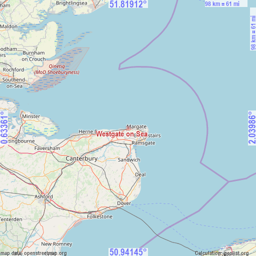
Westgate on Sea GPS coordinates[2]
51° 22' 56.604" North, 1° 20' 12.228" East
| Map corner | latitude | longitude |
|---|---|---|
| Upper-left | 51.81912°, | 0.63361° |
| Center: | 51.38239°, | 1.33673° |
| Lower-right: | 50.94145°, | 2.03986° |
| Map W x H: | 97.6×97.6 km | = 60.6×60.6mi |
| max Lat: | 60.39635° ⇑81.5% North |
| Westgate on Sea: | 51.38239° |
| min Lat: | ⇓18.5% South 34.60088° |
| min Long | Westgate on Sea | max Long |
| -7.64133° | 1.33673° | 32.95536° |
| W 98.6%⇐ | ⇒1.4% E |
Elevation
Elevation of Westgate on Sea is 18 m = 59 ft, and this is 54.9 m = 180 ft below average elevation for this country.
| Max E: |
515 m = 1690 ft | 82.8% |
| Avg. | 72.9 m = 239 ft | |
| Westgate on Sea | 18 m = 59 ft | |
Min E: |
-30 m = -98 ft | 17.2% |
See also: United Kingdom elevation on elevation.city.
Geographical zone
Westgate on Sea is located in North temperate zone (between Tropic of Cancer and the Arctic Circle). Distance of this North polar circle is 1688 km =1048.9 mi to North.| Distance of | km | miles | from Westgate on Sea |
|---|---|---|---|
| North Pole | 4293.9 | 2668.1 | to North |
| Arctic Circle | 1688 | 1048.9 | to North |
| Tropic Cancer | 3107.3 | 1930.8 | to South |
| Equator | 5713.2 | 3550 | to South |


Nearby cities:
15 places around Westgate on Sea: (largest is in red/bold)
• Ash
12.2 km =7.6 mi,  198°
198°
• Birchington-on-Sea
2.3 km =1.4 mi,  251°
251°
• Broadstairs
7.6 km =4.7 mi,  109°
109°
• Deal
18.3 km =11.4 mi,  165°
165°
• Eastry
15.3 km =9.5 mi,  187°
187°
• Herne Bay
14.5 km =9 mi,  265°
265°
• Littlebourne
16.8 km =10.4 mi,  224°
224°
• Margate
3.4 km =2.1 mi,  91°
91°
• Ramsgate
7.7 km =4.8 mi,  132°
132°
• Saint Peters
5.8 km =3.6 mi, 107°
• Sandwich
12.2 km =7.6 mi,  179°
179°
• Sturry
17.5 km =10.9 mi,  238°
238°
• Upstreet
11.8 km =7.3 mi, 237°
• Wingham
14.9 km =9.3 mi,  214°
214°
• Worth
14 km =8.7 mi, 176°
Sources, notices
• [Note1] Compared only with cities in United Kingdom existing in our database
• [Src1] Map data: © OpenStreetMap contributors (CC-BY-SA)
• [Src2] Other city data from geonames.org with taken over terms of usage.
• [Src3] Geographical zone / Annual Mean Temperature by Robert A. Rohde @ Wikipedia
