Margate geodata
Margate (England) is a populated place; located in United Kingdom in Europe/London (GMT+1) time zone. With population of 60,134 people, there are 184 cities with bigger population in this country. Compared to other cities in United Kingdom, 81.5% of cities are located further ↑North; 98.9% of cities are located further ←West and 77.1% of cities have higher elevation than Margate. Note1


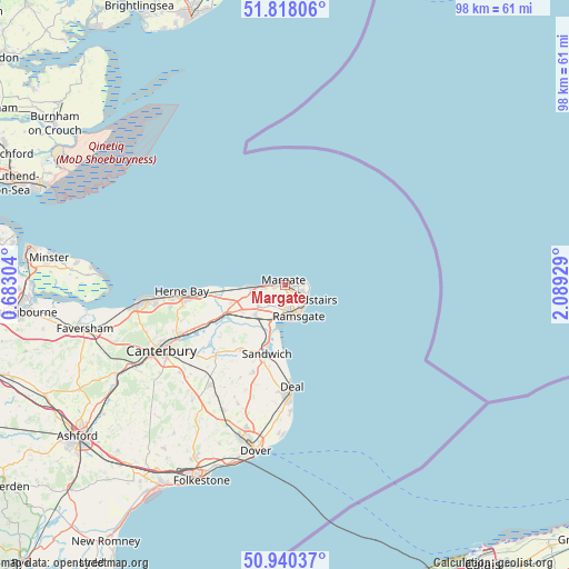
Margate GPS coordinates[2]
51° 22' 52.752" North, 1° 23' 10.212" East
| Map corner | latitude | longitude |
|---|---|---|
| Upper-left | 51.81806°, | 0.68304° |
| Center: | 51.38132°, | 1.38617° |
| Lower-right: | 50.94037°, | 2.08929° |
| Map W x H: | 97.6×97.6 km | = 60.6×60.6mi |
| max Lat: | 60.39635° ⇑81.5% North |
| Margate: | 51.38132° |
| min Lat: | ⇓18.5% South 34.60088° |
| min Long | Margate | max Long |
| -7.64133° | 1.38617° | 32.95536° |
| W 98.9%⇐ | ⇒1.1% E |
Elevation
Elevation of Margate is 24 m = 79 ft, and this is 48.9 m = 160 ft below average elevation for this country.
| Max E: |
515 m = 1690 ft | 77.1% |
| Avg. | 72.9 m = 239 ft | |
| Margate | 24 m = 79 ft | |
Min E: |
-30 m = -98 ft | 22.9% |
See also: Margate elevation on elevation.city.
Geographical zone
Margate is located in North temperate zone (between Tropic of Cancer and the Arctic Circle). Distance of this North polar circle is 1688.1 km =1048.9 mi to North.| Distance of | km | miles | from Margate |
|---|---|---|---|
| North Pole | 4294 | 2668.2 | to North |
| Arctic Circle | 1688.1 | 1048.9 | to North |
| Tropic Cancer | 3107.1 | 1930.7 | to South |
| Equator | 5713.1 | 3550 | to South |


Nearby cities:
15 places around Margate: (largest is in red/bold)
• Ash
13.6 km =8.5 mi,  212°
212°
• Birchington-on-Sea
5.7 km =3.5 mi,  263°
263°
• Broadstairs
4.4 km =2.7 mi,  123°
123°
• Deal
17.6 km =10.9 mi,  175°
175°
• Eastry
16 km =9.9 mi,  199°
199°
• Herne Bay
17.9 km =11.1 mi,  267°
267°
• Littlebourne
19.3 km =12 mi,  232°
232°
• Ramsgate
5.5 km =3.4 mi,  156°
156°
• Saint Peters
2.7 km =1.7 mi,  127°
127°
• Sandwich
12.6 km =7.8 mi, 195°
• Sturry
20.4 km =12.7 mi,  244°
244°
• Upstreet
14.7 km =9.1 mi,  245°
245°
• Westgate on Sea
3.4 km =2.1 mi, 271°
• Wingham
17 km =10.6 mi,  224°
224°
• Worth
14.1 km =8.8 mi,  190°
190°
Sources, notices
• [Note1] Compared only with cities in United Kingdom existing in our database
• [Src1] Map data: © OpenStreetMap contributors (CC-BY-SA)
• [Src2] Other city data from geonames.org with taken over terms of usage.
• [Src3] Geographical zone / Annual Mean Temperature by Robert A. Rohde @ Wikipedia
