Saint Peters geodata
Saint Peters (England) is a populated place; located in United Kingdom in Europe/London (GMT+1) time zone. With population of 125,370 people, there are 75 cities with bigger population in this country. Compared to other cities in United Kingdom, 82.1% of cities are located further ↑North; 99% of cities are located further ←West and 62.4% of cities have higher elevation than Saint Peters. Note1
Administrative division(s):
- Level 1: England
- Level 2: Kent
- Level 3: Thanet District
- Level 4: Broadstairs and St. Peters


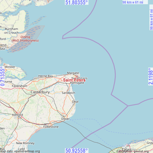
Saint Peters GPS coordinates[2]
51° 22' 0.012" North, 1° 25' 0.012" East
| Map corner | latitude | longitude |
|---|---|---|
| Upper-left | 51.80355°, | 0.71355° |
| Center: | 51.36667°, | 1.41667° |
| Lower-right: | 50.92558°, | 2.1198° |
| Map W x H: | 97.6×97.6 km | = 60.6×60.6mi |
| max Lat: | 60.39635° ⇑82.1% North |
| Saint Peters: | 51.36667° |
| min Lat: | ⇓17.9% South 34.60088° |
| min Long | Saint Peters | max Long |
| -7.64133° | 1.41667° | 32.95536° |
| W 99%⇐ | ⇒1% E |
Elevation
Elevation of Saint Peters is 43 m = 141 ft, and this is 29.9 m = 98 ft below average elevation for this country.
| Max E: |
515 m = 1690 ft | 62.4% |
| Avg. | 72.9 m = 239 ft | |
| Saint Peters | 43 m = 141 ft | |
Min E: |
-30 m = -98 ft | 37.6% |
See also: Saint Peters elevation on elevation.city.
Geographical zone
Saint Peters is located in North temperate zone (between Tropic of Cancer and the Arctic Circle). Distance of this North polar circle is 1689.7 km =1049.9 mi to North.| Distance of | km | miles | from Saint Peters |
|---|---|---|---|
| North Pole | 4295.6 | 2669.2 | to North |
| Arctic Circle | 1689.7 | 1049.9 | to North |
| Tropic Cancer | 3105.5 | 1929.7 | to South |
| Equator | 5711.4 | 3548.9 | to South |


Nearby cities:
15 places around Saint Peters: (largest is in red/bold)
• Ash
13.6 km =8.5 mi,  224°
224°
• Birchington-on-Sea
7.8 km =4.8 mi,  277°
277°
• Broadstairs
1.8 km =1.1 mi,  118°
118°
• Deal
16 km =9.9 mi,  183°
183°
• Eastry
15.4 km =9.6 mi,  209°
209°
• Eythorne
21.6 km =13.4 mi, 209°
• Herne Bay
20 km =12.4 mi,  272°
272°
• Littlebourne
20.2 km =12.6 mi,  239°
239°
• Margate
2.7 km =1.7 mi,  307°
307°
• Ramsgate
3.4 km =2.1 mi, 178°
• Sandwich
11.8 km =7.3 mi, 207°
• Upstreet
16.1 km =10 mi,  253°
253°
• Westgate on Sea
5.8 km =3.6 mi,  287°
287°
• Wingham
17.6 km =10.9 mi,  233°
233°
• Worth
13.2 km =8.2 mi,  201°
201°
Sources, notices
• [Note1] Compared only with cities in United Kingdom existing in our database
• [Src1] Map data: © OpenStreetMap contributors (CC-BY-SA)
• [Src2] Other city data from geonames.org with taken over terms of usage.
• [Src3] Geographical zone / Annual Mean Temperature by Robert A. Rohde @ Wikipedia
