Welling geodata
Welling (England) is a populated place; located in United Kingdom in Europe/London (GMT+1) time zone. With population of 42,500 people, there are 283 cities with bigger population in this country. Compared to other cities in United Kingdom, 78.9% of cities are located further ↑North; 88% of cities are located further ←West and 59.5% of cities have higher elevation than Welling. Note1


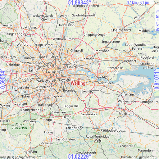
Welling GPS coordinates[2]
51° 27' 44.856" North, 0° 6' 27.324" East
| Map corner | latitude | longitude |
|---|---|---|
| Upper-left | 51.89843°, | -0.59554° |
| Center: | 51.46246°, | 0.10759° |
| Lower-right: | 51.02229°, | 0.81071° |
| Map W x H: | 97.4×97.4 km | = 60.5×60.5mi |
| max Lat: | 60.39635° ⇑78.9% North |
| Welling: | 51.46246° |
| min Lat: | ⇓21.1% South 34.60088° |
| min Long | Welling | max Long |
| -7.64133° | 0.10759° | 32.95536° |
| W 88%⇐ | ⇒12% E |
Elevation
Elevation of Welling is 47 m = 154 ft, and this is 25.9 m = 85 ft below average elevation for this country.
| Max E: |
515 m = 1690 ft | 59.5% |
| Avg. | 72.9 m = 239 ft | |
| Welling | 47 m = 154 ft | |
Min E: |
-30 m = -98 ft | 40.5% |
See also: Welling elevation on elevation.city.
Geographical zone
Welling is located in North temperate zone (between Tropic of Cancer and the Arctic Circle). Distance of this North polar circle is 1679.1 km =1043.3 mi to North.| Distance of | km | miles | from Welling |
|---|---|---|---|
| North Pole | 4285 | 2662.6 | to North |
| Arctic Circle | 1679.1 | 1043.3 | to North |
| Tropic Cancer | 3116.2 | 1936.3 | to South |
| Equator | 5722.1 | 3555.5 | to South |


Nearby cities:
15 places around Welling: (largest is in red/bold)
• Abbey Wood
2.7 km =1.7 mi,  359°
359°
• Barking
8.1 km =5 mi,  347°
347°
• Belvedere
4.4 km =2.7 mi,  43°
43°
• Bexley
3.7 km =2.3 mi,  129°
129°
• Bexleyheath
2.2 km =1.4 mi,  88°
88°
• Blackheath
6.9 km =4.3 mi,  272°
272°
• Bromley
9 km =5.6 mi,  225°
225°
• Catford
9.1 km =5.7 mi,  257°
257°
• Chislehurst
5.7 km =3.5 mi,  208°
208°
• Dartford
7.6 km =4.7 mi,  103°
103°
• East Ham
8.8 km =5.5 mi,  333°
333°
• Erith
5.2 km =3.2 mi,  63°
63°
• Sidcup
4 km =2.5 mi,  183°
183°
• Swanley
8.6 km =5.3 mi,  147°
147°
• Woolwich
4.3 km =2.7 mi,  316°
316°
Sources, notices
• [Note1] Compared only with cities in United Kingdom existing in our database
• [Src1] Map data: © OpenStreetMap contributors (CC-BY-SA)
• [Src2] Other city data from geonames.org with taken over terms of usage.
• [Src3] Geographical zone / Annual Mean Temperature by Robert A. Rohde @ Wikipedia
