Dartford geodata
Dartford (England) is a populated place; located in United Kingdom in Europe/London (GMT+1) time zone. With population of 56,694 people, there are 201 cities with bigger population in this country. Compared to other cities in United Kingdom, 79.5% of cities are located further ↑North; 89.3% of cities are located further ←West and 94.9% of cities have higher elevation than Dartford. Note1


Dartford GPS coordinates[2]
51° 26' 47.652" North, 0° 12' 51.228" East
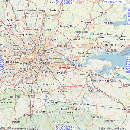
| Map corner | latitude | longitude |
|---|---|---|
| Upper-left | 51.88269°, | -0.4889° |
| Center: | 51.44657°, | 0.21423° |
| Lower-right: | 51.00625°, | 0.91735° |
| Map W x H: | 97.5×97.4 km | = 60.6×60.5mi |
| max Lat: | 60.39635° ⇑79.5% North |
| Dartford: | 51.44657° |
| min Lat: | ⇓20.5% South 34.60088° |
| min Long | Dartford | max Long |
| -7.64133° | 0.21423° | 32.95536° |
| W 89.3%⇐ | ⇒10.7% E |
Elevation
Elevation of Dartford is 8 m = 26 ft, and this is 64.9 m = 213 ft below average elevation for this country.
| Max E: |
515 m = 1690 ft | 94.9% |
| Avg. | 72.9 m = 239 ft | |
| Dartford | 8 m = 26 ft | |
Min E: |
-30 m = -98 ft | 5.1% |
See also: Dartford elevation on elevation.city.
Geographical zone
Dartford is located in North temperate zone (between Tropic of Cancer and the Arctic Circle). Distance of this North polar circle is 1680.9 km =1044.5 mi to North.| Distance of | km | miles | from Dartford |
|---|---|---|---|
| North Pole | 4286.7 | 2663.6 | to North |
| Arctic Circle | 1680.9 | 1044.5 | to North |
| Tropic Cancer | 3114.4 | 1935.2 | to South |
| Equator | 5720.3 | 3554.4 | to South |


Nearby cities:
15 places around Dartford: (largest is in red/bold)
• Aveley
6.5 km =4 mi,  23°
23°
• Belvedere
6.6 km =4.1 mi,  318°
318°
• Bexley
4.6 km =2.9 mi,  263°
263°
• Bexleyheath
5.5 km =3.4 mi,  289°
289°
• Chafford Hundred
7.3 km =4.5 mi,  49°
49°
• Darenth
4.1 km =2.5 mi,  132°
132°
• Erith
4.9 km =3 mi,  326°
326°
• Greenhithe
4.9 km =3 mi,  85°
85°
• Horton Kirby
6.1 km =3.8 mi,  159°
159°
• Purfleet
4.6 km =2.9 mi,  25°
25°
• Stone
3.5 km =2.2 mi,  83°
83°
• Swanley
6.2 km =3.9 mi,  207°
207°
• Swanscombe
6.7 km =4.2 mi, 89°
• Welling
7.6 km =4.7 mi,  283°
283°
• West Thurrock
5.6 km =3.5 mi, 50°
Sources, notices
• [Note1] Compared only with cities in United Kingdom existing in our database
• [Src1] Map data: © OpenStreetMap contributors (CC-BY-SA)
• [Src2] Other city data from geonames.org with taken over terms of usage.
• [Src3] Geographical zone / Annual Mean Temperature by Robert A. Rohde @ Wikipedia
