Waterlooville geodata
Waterlooville (England) is a populated place; located in United Kingdom in Europe/London (GMT+1) time zone. With population of 64,350 people, there are 165 cities with bigger population in this country. Compared to other cities in United Kingdom, 93.7% of cities are located further ↑North; 66.3% of cities are located further ←West and 54.4% of cities have higher elevation than Waterlooville. Note1


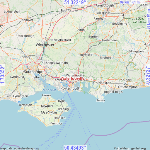
Waterlooville GPS coordinates[2]
50° 52' 50.412" North, 1° 1' 49.44" West
| Map corner | latitude | longitude |
|---|---|---|
| Upper-left | 51.32219°, | -1.73352° |
| Center: | 50.88067°, | -1.0304° |
| Lower-right: | 50.43493°, | -0.32727° |
| Map W x H: | 98.7×98.7 km | = 61.3×61.3mi |
| max Lat: | 60.39635° ⇑93.7% North |
| Waterlooville: | 50.88067° |
| min Lat: | ⇓6.3% South 34.60088° |
| min Long | Waterlooville | max Long |
| -7.64133° | -1.0304° | 32.95536° |
| W 66.3%⇐ | ⇒33.7% E |
Elevation
Elevation of Waterlooville is 54 m = 177 ft, and this is 18.9 m = 62 ft below average elevation for this country.
| Max E: |
515 m = 1690 ft | 54.4% |
| Avg. | 72.9 m = 239 ft | |
| Waterlooville | 54 m = 177 ft | |
Min E: |
-30 m = -98 ft | 45.6% |
See also: Waterlooville elevation on elevation.city.
Geographical zone
Waterlooville is located in North temperate zone (between Tropic of Cancer and the Arctic Circle). Distance of this North polar circle is 1743.8 km =1083.5 mi to North.| Distance of | km | miles | from Waterlooville |
|---|---|---|---|
| North Pole | 4349.7 | 2702.8 | to North |
| Arctic Circle | 1743.8 | 1083.5 | to North |
| Tropic Cancer | 3051.5 | 1896.1 | to South |
| Equator | 5657.4 | 3515.3 | to South |


Nearby cities:
15 places around Waterlooville: (largest is in red/bold)
• Buriton
12 km =7.5 mi,  28°
28°
• Cosham
4.4 km =2.7 mi,  211°
211°
• Cowplain
1.7 km =1.1 mi, 29°
• Denmead
3.7 km =2.3 mi,  314°
314°
• Droxford
11.7 km =7.3 mi,  319°
319°
• Emsworth
7.5 km =4.7 mi,  119°
119°
• Fareham
10.9 km =6.8 mi,  252°
252°
• Gosport
11.8 km =7.3 mi,  216°
216°
• Hambledon
6.7 km =4.2 mi,  327°
327°
• Havant
4.1 km =2.5 mi,  130°
130°
• Hayling Island
11.6 km =7.2 mi,  158°
158°
• Portsmouth
10 km =6.2 mi, 205°
• South Hayling
11 km =6.8 mi, 160°
• Southsea
10.6 km =6.6 mi,  201°
201°
• Wickham
11.3 km =7 mi,  280°
280°
Sources, notices
• [Note1] Compared only with cities in United Kingdom existing in our database
• [Src1] Map data: © OpenStreetMap contributors (CC-BY-SA)
• [Src2] Other city data from geonames.org with taken over terms of usage.
• [Src3] Geographical zone / Annual Mean Temperature by Robert A. Rohde @ Wikipedia
