Portsmouth geodata
Portsmouth (England) is a seat of a second-order administrative division; located in United Kingdom in Europe/London (GMT+0) time zone. With population of 194,150 people, there are 40 cities with bigger population in this country. Compared to other cities in United Kingdom, 95.3% of cities are located further ↑North; 64.8% of cities are located further ←West and 97.5% of cities have higher elevation than Portsmouth. Note1


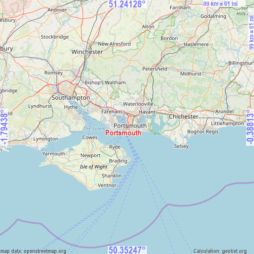
Portsmouth GPS coordinates[2]
50° 47' 56.364" North, 1° 5' 28.5" West
| Map corner | latitude | longitude |
|---|---|---|
| Upper-left | 51.24128°, | -1.79438° |
| Center: | 50.79899°, | -1.09125° |
| Lower-right: | 50.35247°, | -0.38813° |
| Map W x H: | 98.8×98.8 km | = 61.4×61.4mi |
| max Lat: | 60.39635° ⇑95.3% North |
| Portsmouth: | 50.79899° |
| min Lat: | ⇓4.7% South 34.60088° |
| min Long | Portsmouth | max Long |
| -7.64133° | -1.09125° | 32.95536° |
| W 64.8%⇐ | ⇒35.2% E |
Elevation
Elevation of Portsmouth is 6 m = 20 ft, and this is 66.9 m = 219 ft below average elevation for this country.
| Max E: |
515 m = 1690 ft | 97.5% |
| Avg. | 72.9 m = 239 ft | |
| Portsmouth | 6 m = 20 ft | |
Min E: |
-30 m = -98 ft | 2.5% |
See also: Portsmouth elevation on elevation.city.
Geographical zone
Portsmouth is located in North temperate zone (between Tropic of Cancer and the Arctic Circle). Distance of this North polar circle is 1752.9 km =1089.2 mi to North.| Distance of | km | miles | from Portsmouth |
|---|---|---|---|
| North Pole | 4358.7 | 2708.4 | to North |
| Arctic Circle | 1752.9 | 1089.2 | to North |
| Tropic Cancer | 3042.4 | 1890.5 | to South |
| Equator | 5648.3 | 3509.7 | to South |


Nearby cities:
15 places around Portsmouth: (largest is in red/bold)
• Cosham
5.6 km =3.5 mi,  20°
20°
• Cowplain
11.8 km =7.3 mi,  25°
25°
• Denmead
11.8 km =7.3 mi,  8°
8°
• Emsworth
12.1 km =7.5 mi,  63°
63°
• Fareham
8.5 km =5.3 mi,  313°
313°
• Gosport
2.7 km =1.7 mi,  260°
260°
• Havant
9.8 km =6.1 mi,  49°
49°
• Hayling Island
8.8 km =5.5 mi,  101°
101°
• Lee-on-the-Solent
7.8 km =4.8 mi,  272°
272°
• Ryde
9.1 km =5.7 mi,  213°
213°
• Seaview
8.9 km =5.5 mi,  189°
189°
• South Hayling
8.1 km =5 mi, 98°
• Southsea
0.9 km =0.6 mi,  154°
154°
• St. Helens
11.4 km =7.1 mi, 187°
• Waterlooville
10 km =6.2 mi, 25°
Sources, notices
• [Note1] Compared only with cities in United Kingdom existing in our database
• [Src1] Map data: © OpenStreetMap contributors (CC-BY-SA)
• [Src2] Other city data from geonames.org with taken over terms of usage.
• [Src3] Geographical zone / Annual Mean Temperature by Robert A. Rohde @ Wikipedia
