Havant geodata
Havant (England) is a populated place; located in United Kingdom in Europe/London (GMT+0) time zone. With population of 45,574 people, there are 262 cities with bigger population in this country. Compared to other cities in United Kingdom, 94.1% of cities are located further ↑North; 67% of cities are located further ←West and 89.9% of cities have higher elevation than Havant. Note1


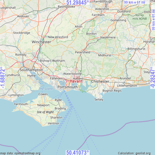
Havant GPS coordinates[2]
50° 51' 24.12" North, 0° 59' 8.124" West
| Map corner | latitude | longitude |
|---|---|---|
| Upper-left | 51.29845°, | -1.68872° |
| Center: | 50.8567°, | -0.98559° |
| Lower-right: | 50.41073°, | -0.28247° |
| Map W x H: | 98.7×98.7 km | = 61.3×61.3mi |
| max Lat: | 60.39635° ⇑94.1% North |
| Havant: | 50.8567° |
| min Lat: | ⇓5.9% South 34.60088° |
| min Long | Havant | max Long |
| -7.64133° | -0.98559° | 32.95536° |
| W 67%⇐ | ⇒33% E |
Elevation
Elevation of Havant is 12 m = 39 ft, and this is 60.9 m = 200 ft below average elevation for this country.
| Max E: |
515 m = 1690 ft | 89.9% |
| Avg. | 72.9 m = 239 ft | |
| Havant | 12 m = 39 ft | |
Min E: |
-30 m = -98 ft | 10.1% |
See also: Havant elevation on elevation.city.
Geographical zone
Havant is located in North temperate zone (between Tropic of Cancer and the Arctic Circle). Distance of this North polar circle is 1746.4 km =1085.2 mi to North.| Distance of | km | miles | from Havant |
|---|---|---|---|
| North Pole | 4352.3 | 2704.4 | to North |
| Arctic Circle | 1746.4 | 1085.2 | to North |
| Tropic Cancer | 3048.8 | 1894.4 | to South |
| Equator | 5654.7 | 3513.7 | to South |


Nearby cities:
15 places around Havant: (largest is in red/bold)
• Birdham
12.8 km =8 mi,  121°
121°
• Bosham
9.7 km =6 mi,  107°
107°
• Cosham
5.6 km =3.5 mi,  258°
258°
• Cowplain
4.7 km =2.9 mi,  331°
331°
• Denmead
7.8 km =4.8 mi,  312°
312°
• East Wittering
12.4 km =7.7 mi,  141°
141°
• Emsworth
3.6 km =2.2 mi, 106°
• Gosport
12.2 km =7.6 mi,  235°
235°
• Hambledon
10.7 km =6.6 mi,  321°
321°
• Hayling Island
8.2 km =5.1 mi,  171°
171°
• Portsmouth
9.8 km =6.1 mi,  229°
229°
• South Hayling
7.7 km =4.8 mi,  175°
175°
• Southsea
10.1 km =6.3 mi,  224°
224°
• Waterlooville
4.1 km =2.5 mi, 310°
• West Wittering
10.5 km =6.5 mi, 143°
Sources, notices
• [Note1] Compared only with cities in United Kingdom existing in our database
• [Src1] Map data: © OpenStreetMap contributors (CC-BY-SA)
• [Src2] Other city data from geonames.org with taken over terms of usage.
• [Src3] Geographical zone / Annual Mean Temperature by Robert A. Rohde @ Wikipedia
