Thursby geodata
Thursby (England) is a populated place; located in United Kingdom in Europe/London (GMT+1) time zone. With population of 846 people, there are 3936 cities with bigger population in this country. Compared to other cities in United Kingdom, 85.4% of cities are located further ↓South; 76.3% of cities are located further →East and 68.3% of cities have higher elevation than Thursby. Note1
Administrative division(s):
- Level 1: England
- Level 2: Cumbria
- Level 3: Allerdale District
- Level 4: Thursby


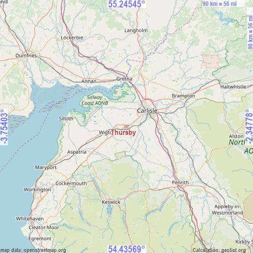
Thursby GPS coordinates[2]
54° 50' 33.36" North, 3° 3' 3.24" West
| Map corner | latitude | longitude |
|---|---|---|
| Upper-left | 55.24545°, | -3.75403° |
| Center: | 54.8426°, | -3.0509° |
| Lower-right: | 54.43569°, | -2.34778° |
| Map W x H: | 90×90 km | = 55.9×55.9mi |
| max Lat: | 60.39635° ⇑14.6% North |
| Thursby: | 54.8426° |
| min Lat: | ⇓85.4% South 34.60088° |
| min Long | Thursby | max Long |
| -7.64133° | -3.0509° | 32.95536° |
| W 23.7%⇐ | ⇒76.3% E |
Elevation
Elevation of Thursby is 35 m = 115 ft, and this is 37.9 m = 124 ft below average elevation for this country.
| Max E: |
515 m = 1690 ft | 68.3% |
| Avg. | 72.9 m = 239 ft | |
| Thursby | 35 m = 115 ft | |
Min E: |
-30 m = -98 ft | 31.7% |
See also: United Kingdom elevation on elevation.city.
Geographical zone
Thursby is located in North temperate zone (between Tropic of Cancer and the Arctic Circle). Distance of this North polar circle is 1303.2 km =809.8 mi to North.| Distance of | km | miles | from Thursby |
|---|---|---|---|
| North Pole | 3909.1 | 2429 | to North |
| Arctic Circle | 1303.2 | 809.8 | to North |
| Tropic Cancer | 3492 | 2169.8 | to South |
| Equator | 6097.9 | 3789.1 | to South |


Nearby cities:
15 places around Thursby: (largest is in red/bold)
• Annan
20.9 km =13 mi,  320°
320°
• Aspatria
19.7 km =12.2 mi,  244°
244°
• Brampton
23.6 km =14.7 mi,  59°
59°
• Burgh by Sands
8.8 km =5.5 mi,  357°
357°
• Carlisle
9.3 km =5.8 mi,  51°
51°
• Dalston
4.2 km =2.6 mi,  90°
90°
• Denton Holme
8.5 km =5.3 mi, 56°
• Eastriggs
18 km =11.2 mi,  332°
332°
• Gretna
16.8 km =10.4 mi, 356°
• Greystoke
22.4 km =13.9 mi,  149°
149°
• Longtown
19.3 km =12 mi,  16°
16°
• Scotby
12.5 km =7.8 mi, 64°
• Silloth
21.5 km =13.4 mi,  277°
277°
• Wetheral
14.7 km =9.1 mi,  71°
71°
• Wigton
7.3 km =4.5 mi,  254°
254°
Sources, notices
• [Note1] Compared only with cities in United Kingdom existing in our database
• [Src1] Map data: © OpenStreetMap contributors (CC-BY-SA)
• [Src2] Other city data from geonames.org with taken over terms of usage.
• [Src3] Geographical zone / Annual Mean Temperature by Robert A. Rohde @ Wikipedia
