Brampton geodata
Brampton (England) is a populated place; located in United Kingdom in Europe/London (GMT+1) time zone. With population of 4,001 people, there are 1840 cities with bigger population in this country. Compared to other cities in United Kingdom, 86.2% of cities are located further ↓South; 69.5% of cities are located further →East and 57.1% of cities have lower elevation than Brampton. Note1
Administrative division(s):
- Level 1: England
- Level 2: Cumbria
- Level 3: Carlisle District
- Level 4: Brampton


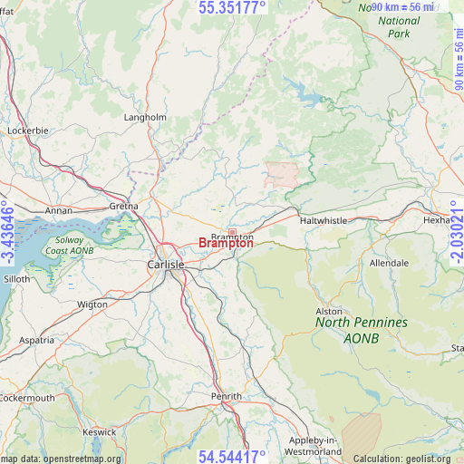
Brampton GPS coordinates[2]
54° 57' 0" North, 2° 43' 59.988" West
| Map corner | latitude | longitude |
|---|---|---|
| Upper-left | 55.35177°, | -3.43646° |
| Center: | 54.95°, | -2.73333° |
| Lower-right: | 54.54417°, | -2.03021° |
| Map W x H: | 89.8×89.8 km | = 55.8×55.8mi |
| max Lat: | 60.39635° ⇑13.8% North |
| Brampton: | 54.95° |
| min Lat: | ⇓86.2% South 34.60088° |
| min Long | Brampton | max Long |
| -7.64133° | -2.73333° | 32.95536° |
| W 30.5%⇐ | ⇒69.5% E |
Elevation
Elevation of Brampton is 72 m = 236 ft, and this is 0.90000000000001 m = 3 ft below average elevation for this country.
| Max E: |
515 m = 1690 ft | 42.9% |
| Avg. | 72.9 m = 239 ft | |
| Brampton | 72 m = 236 ft | |
Min E: |
-30 m = -98 ft | 57.1% |
See also: United Kingdom elevation on elevation.city.
Geographical zone
Brampton is located in North temperate zone (between Tropic of Cancer and the Arctic Circle). Distance of this North polar circle is 1291.3 km =802.4 mi to North.| Distance of | km | miles | from Brampton |
|---|---|---|---|
| North Pole | 3897.2 | 2421.6 | to North |
| Arctic Circle | 1291.3 | 802.4 | to North |
| Tropic Cancer | 3503.9 | 2177.2 | to South |
| Equator | 6109.9 | 3796.5 | to South |


Nearby cities:
15 places around Brampton: (largest is in red/bold)
• Alston
24.5 km =15.2 mi,  129°
129°
• Bardon Mill
25.1 km =15.6 mi,  83°
83°
• Burgh by Sands
20.9 km =13 mi,  261°
261°
• Carlisle
14.4 km =8.9 mi,  245°
245°
• Dalston
20.1 km =12.5 mi,  233°
233°
• Denton Holme
15.1 km =9.4 mi,  241°
241°
• Greenhead
14 km =8.7 mi, 82°
• Gretna
21.8 km =13.5 mi,  282°
282°
• Haltwhistle
17.8 km =11.1 mi, 82°
• Lazonby
22.6 km =14 mi,  175°
175°
• Longtown
16.3 km =10.1 mi,  293°
293°
• Newcastleton
26 km =16.2 mi,  348°
348°
• Scotby
11.2 km =7 mi, 233°
• Thursby
23.6 km =14.7 mi, 239°
• Wetheral
9.7 km =6 mi,  221°
221°
Sources, notices
• [Note1] Compared only with cities in United Kingdom existing in our database
• [Src1] Map data: © OpenStreetMap contributors (CC-BY-SA)
• [Src2] Other city data from geonames.org with taken over terms of usage.
• [Src3] Geographical zone / Annual Mean Temperature by Robert A. Rohde @ Wikipedia
