Taunton geodata
Taunton (England) is a seat of a second-order administrative division; located in United Kingdom in Europe/London (GMT+1) time zone. With population of 64,621 people, there are 164 cities with bigger population in this country. Compared to other cities in United Kingdom, 91% of cities are located further ↑North; 77.1% of cities are located further →East and 79% of cities have higher elevation than Taunton. Note1


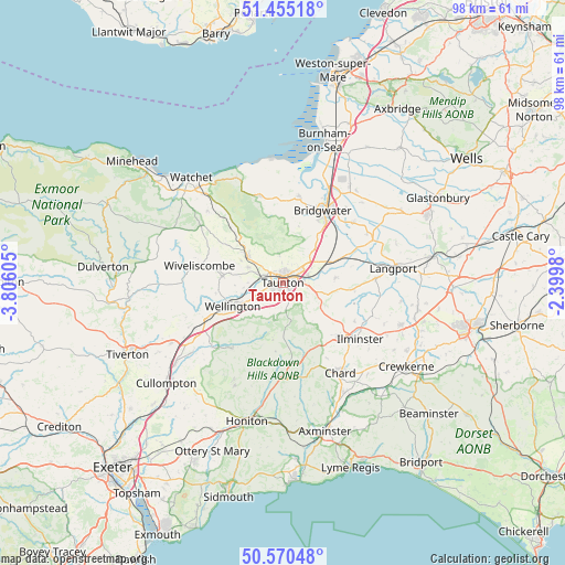
Taunton GPS coordinates[2]
51° 0' 53.784" North, 3° 6' 10.548" West
| Map corner | latitude | longitude |
|---|---|---|
| Upper-left | 51.45518°, | -3.80605° |
| Center: | 51.01494°, | -3.10293° |
| Lower-right: | 50.57048°, | -2.3998° |
| Map W x H: | 98.4×98.4 km | = 61.1×61.1mi |
| max Lat: | 60.39635° ⇑91% North |
| Taunton: | 51.01494° |
| min Lat: | ⇓9% South 34.60088° |
| min Long | Taunton | max Long |
| -7.64133° | -3.10293° | 32.95536° |
| W 22.9%⇐ | ⇒77.1% E |
Elevation
Elevation of Taunton is 22 m = 72 ft, and this is 50.9 m = 167 ft below average elevation for this country.
| Max E: |
515 m = 1690 ft | 79% |
| Avg. | 72.9 m = 239 ft | |
| Taunton | 22 m = 72 ft | |
Min E: |
-30 m = -98 ft | 21% |
See also: Taunton elevation on elevation.city.
Geographical zone
Taunton is located in North temperate zone (between Tropic of Cancer and the Arctic Circle). Distance of this North polar circle is 1728.8 km =1074.2 mi to North.| Distance of | km | miles | from Taunton |
|---|---|---|---|
| North Pole | 4334.7 | 2693.5 | to North |
| Arctic Circle | 1728.8 | 1074.2 | to North |
| Tropic Cancer | 3066.4 | 1905.4 | to South |
| Equator | 5672.3 | 3524.6 | to South |


Nearby cities:
15 places around Taunton: (largest is in red/bold)
• Bishops Lydeard
7.7 km =4.8 mi,  309°
309°
• Bridgwater
14.4 km =8.9 mi,  28°
28°
• Creech Saint Michael
4.6 km =2.9 mi,  78°
78°
• Curry Rivel
16.5 km =10.3 mi,  86°
86°
• Fivehead
12.8 km =8 mi,  96°
96°
• Hemyock
14.4 km =8.9 mi,  217°
217°
• Henlade
4.3 km =2.7 mi, 95°
• Ilton
14.2 km =8.8 mi,  118°
118°
• Langford Budville
11.8 km =7.3 mi,  260°
260°
• Milverton
10.5 km =6.5 mi,  275°
275°
• Nether Stowey
15.6 km =9.7 mi,  346°
346°
• North Curry
9.2 km =5.7 mi, 84°
• North Petherton
10.6 km =6.6 mi,  35°
35°
• Westonzoyland
16 km =9.9 mi,  49°
49°
• Wiveliscombe
15 km =9.3 mi, 281°
Sources, notices
• [Note1] Compared only with cities in United Kingdom existing in our database
• [Src1] Map data: © OpenStreetMap contributors (CC-BY-SA)
• [Src2] Other city data from geonames.org with taken over terms of usage.
• [Src3] Geographical zone / Annual Mean Temperature by Robert A. Rohde @ Wikipedia
