Sunderland geodata
Sunderland (England) is a seat of a second-order administrative division; located in United Kingdom in Europe/London (GMT+1) time zone. With population of 335,415 people, there are 14 cities with bigger population in this country. Compared to other cities in United Kingdom, 85.9% of cities are located further ↓South; 58.1% of cities are located further ←West and 67.5% of cities have higher elevation than Sunderland. Note1


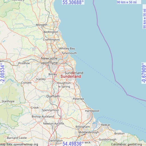
Sunderland GPS coordinates[2]
54° 54' 16.74" North, 1° 22' 55.992" West
| Map corner | latitude | longitude |
|---|---|---|
| Upper-left | 55.30688°, | -2.08534° |
| Center: | 54.90465°, | -1.38222° |
| Lower-right: | 54.49836°, | -0.67909° |
| Map W x H: | 89.9×89.9 km | = 55.9×55.9mi |
| max Lat: | 60.39635° ⇑14.1% North |
| Sunderland: | 54.90465° |
| min Lat: | ⇓85.9% South 34.60088° |
| min Long | Sunderland | max Long |
| -7.64133° | -1.38222° | 32.95536° |
| W 58.1%⇐ | ⇒41.9% E |
Elevation
Elevation of Sunderland is 36 m = 118 ft, and this is 36.9 m = 121 ft below average elevation for this country.
| Max E: |
515 m = 1690 ft | 67.5% |
| Avg. | 72.9 m = 239 ft | |
| Sunderland | 36 m = 118 ft | |
Min E: |
-30 m = -98 ft | 32.5% |
See also: Sunderland elevation on elevation.city.
Geographical zone
Sunderland is located in North temperate zone (between Tropic of Cancer and the Arctic Circle). Distance of this North polar circle is 1296.3 km =805.5 mi to North.| Distance of | km | miles | from Sunderland |
|---|---|---|---|
| North Pole | 3902.2 | 2424.7 | to North |
| Arctic Circle | 1296.3 | 805.5 | to North |
| Tropic Cancer | 3498.9 | 2174.1 | to South |
| Equator | 6104.8 | 3793.3 | to South |


Nearby cities:
15 places around Sunderland: (largest is in red/bold)
• East Boldon
5.3 km =3.3 mi,  326°
326°
• East Rainton
10.8 km =6.7 mi,  215°
215°
• Hawthorn
11.8 km =7.3 mi,  169°
169°
• Hebburn
11.4 km =7.1 mi,  311°
311°
• Hetton-Le-Hole
10.7 km =6.6 mi,  203°
203°
• Houghton-Le-Spring
8.9 km =5.5 mi, 216°
• Jarrow
10.6 km =6.6 mi,  322°
322°
• Murton
9.6 km =6 mi,  183°
183°
• Ryhope
3.8 km =2.4 mi, 168°
• Seaham
7.7 km =4.8 mi,  162°
162°
• South Hetton
11.8 km =7.3 mi,  187°
187°
• South Shields
10.9 km =6.8 mi,  342°
342°
• The Boldons
6.2 km =3.9 mi, 312°
• Washington
8.6 km =5.3 mi,  266°
266°
• Whitburn
5.5 km =3.4 mi,  9°
9°
Sources, notices
• [Note1] Compared only with cities in United Kingdom existing in our database
• [Src1] Map data: © OpenStreetMap contributors (CC-BY-SA)
• [Src2] Other city data from geonames.org with taken over terms of usage.
• [Src3] Geographical zone / Annual Mean Temperature by Robert A. Rohde @ Wikipedia
