Staveley geodata
Staveley (England) is a populated place; located in United Kingdom in Europe/London (GMT+1) time zone. With population of 1,384 people, there are 3162 cities with bigger population in this country. Compared to other cities in United Kingdom, 81.1% of cities are located further ↓South; 71.5% of cities are located further →East and 71.7% of cities have lower elevation than Staveley. Note1
Administrative division(s):
- Level 1: England
- Level 2: Cumbria
- Level 3: South Lakeland District
- Level 4: Nether Staveley


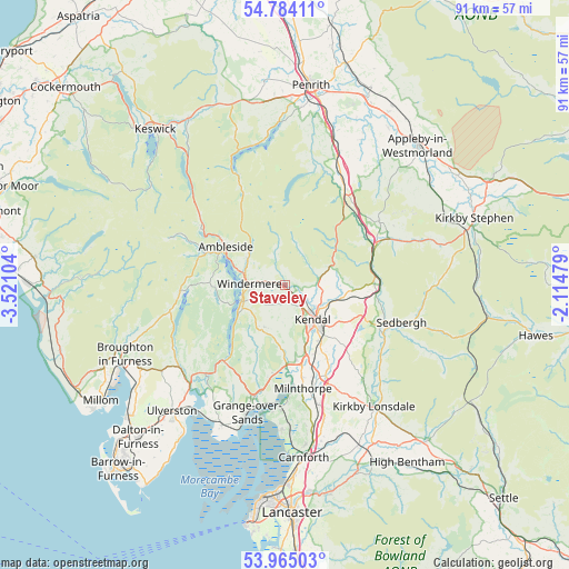
Staveley GPS coordinates[2]
54° 22' 35.796" North, 2° 49' 4.476" West
| Map corner | latitude | longitude |
|---|---|---|
| Upper-left | 54.78411°, | -3.52104° |
| Center: | 54.37661°, | -2.81791° |
| Lower-right: | 53.96503°, | -2.11479° |
| Map W x H: | 91.1×91.1 km | = 56.6×56.6mi |
| max Lat: | 60.39635° ⇑18.9% North |
| Staveley: | 54.37661° |
| min Lat: | ⇓81.1% South 34.60088° |
| min Long | Staveley | max Long |
| -7.64133° | -2.81791° | 32.95536° |
| W 28.5%⇐ | ⇒71.5% E |
Elevation
Elevation of Staveley is 99 m = 325 ft, and this is 26.1 m = 86 ft above average elevation for this country.
| Max E: |
515 m = 1690 ft | 28.3% |
| Staveley | 99 m 325 ft | |
| Avg. | 72.9 m = 239 ft | |
Min E: |
-30 m = -98 ft | 71.7% |
See also: United Kingdom elevation on elevation.city.
Geographical zone
Staveley is located in North temperate zone (between Tropic of Cancer and the Arctic Circle). Distance of this North polar circle is 1355.1 km =842 mi to North.| Distance of | km | miles | from Staveley |
|---|---|---|---|
| North Pole | 3960.9 | 2461.2 | to North |
| Arctic Circle | 1355.1 | 842 | to North |
| Tropic Cancer | 3440.2 | 2137.6 | to South |
| Equator | 6046.1 | 3756.9 | to South |


Nearby cities:
15 places around Staveley: (largest is in red/bold)
• Ambleside
11.2 km =7 mi,  303°
303°
• Arnside
19.5 km =12.1 mi,  183°
183°
• Backbarrow
17.4 km =10.8 mi,  219°
219°
• Burneside
4.5 km =2.8 mi,  126°
126°
• Coniston
16.7 km =10.4 mi,  267°
267°
• Grange-over-Sands
22.4 km =13.9 mi,  198°
198°
• Heversham
15.2 km =9.4 mi,  169°
169°
• Kendal
7.2 km =4.5 mi,  140°
140°
• Levens
12.1 km =7.5 mi, 170°
• Lindale
18.4 km =11.4 mi, 195°
• Milnthorpe
16.8 km =10.4 mi, 169°
• Sedbergh
19.9 km =12.4 mi,  107°
107°
• Shap
19.5 km =12.1 mi,  28°
28°
• Silverdale
23.3 km =14.5 mi, 179°
• Windermere
5.8 km =3.6 mi, 274°
Sources, notices
• [Note1] Compared only with cities in United Kingdom existing in our database
• [Src1] Map data: © OpenStreetMap contributors (CC-BY-SA)
• [Src2] Other city data from geonames.org with taken over terms of usage.
• [Src3] Geographical zone / Annual Mean Temperature by Robert A. Rohde @ Wikipedia
