Stanford-le-Hope geodata
Stanford-le-Hope (England) is a populated place; located in United Kingdom in Europe/London (GMT+0) time zone. With population of 28,725 people, there are 426 cities with bigger population in this country. Compared to other cities in United Kingdom, 77% of cities are located further ↑North; 91.7% of cities are located further ←West and 88.2% of cities have higher elevation than Stanford-le-Hope. Note1


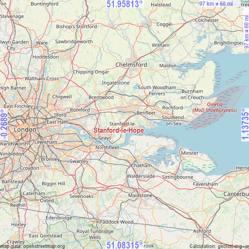
Stanford-le-Hope GPS coordinates[2]
51° 31' 21.864" North, 0° 26' 3.192" East
| Map corner | latitude | longitude |
|---|---|---|
| Upper-left | 51.95813°, | -0.2689° |
| Center: | 51.52274°, | 0.43422° |
| Lower-right: | 51.08315°, | 1.13735° |
| Map W x H: | 97.3×97.3 km | = 60.5×60.5mi |
| max Lat: | 60.39635° ⇑77% North |
| Stanford-le-Hope: | 51.52274° |
| min Lat: | ⇓23% South 34.60088° |
| min Long | Stanford-le-Hop | max Long |
| -7.64133° | 0.43422° | 32.95536° |
| W 91.7%⇐ | ⇒8.3% E |
Elevation
Elevation of Stanford-le-Hope is 13 m = 43 ft, and this is 59.9 m = 197 ft below average elevation for this country.
| Max E: |
515 m = 1690 ft | 88.2% |
| Avg. | 72.9 m = 239 ft | |
| Stanford-le-Hope | 13 m = 43 ft | |
Min E: |
-30 m = -98 ft | 11.8% |
See also: United Kingdom elevation on elevation.city.
Geographical zone
Stanford-le-Hope is located in North temperate zone (between Tropic of Cancer and the Arctic Circle). Distance of this North polar circle is 1672.4 km =1039.2 mi to North.| Distance of | km | miles | from Stanford-le-Hope |
|---|---|---|---|
| North Pole | 4278.3 | 2658.4 | to North |
| Arctic Circle | 1672.4 | 1039.2 | to North |
| Tropic Cancer | 3122.9 | 1940.5 | to South |
| Equator | 5728.8 | 3559.7 | to South |


Nearby cities:
15 places around Stanford-le-Hope: (largest is in red/bold)
• Basildon
5.3 km =3.3 mi,  17°
17°
• Bulphan
5.7 km =3.5 mi,  297°
297°
• Canvey Island
10.1 km =6.3 mi,  90°
90°
• Chadwell St Mary
6.7 km =4.2 mi,  226°
226°
• Chafford Hundred
10.4 km =6.5 mi,  248°
248°
• Cliffe
8.1 km =5 mi,  146°
146°
• Cooling
9.8 km =6.1 mi,  140°
140°
• East Tilbury
4.8 km =3 mi,  194°
194°
• Gravesend
10 km =6.2 mi,  205°
205°
• Grays
9.2 km =5.7 mi,  235°
235°
• Horndon on the Hill
2 km =1.2 mi,  272°
272°
• Orsett
4.8 km =3 mi,  255°
255°
• Pitsea
6.9 km =4.3 mi,  48°
48°
• South Benfleet
9.3 km =5.8 mi,  68°
68°
• Tilbury
8.5 km =5.3 mi,  218°
218°
Sources, notices
• [Note1] Compared only with cities in United Kingdom existing in our database
• [Src1] Map data: © OpenStreetMap contributors (CC-BY-SA)
• [Src2] Other city data from geonames.org with taken over terms of usage.
• [Src3] Geographical zone / Annual Mean Temperature by Robert A. Rohde @ Wikipedia
