Sleights geodata
Sleights (England) is a populated place; located in United Kingdom in Europe/London (GMT+1) time zone. With population of 1,972 people, there are 2646 cities with bigger population in this country. Compared to other cities in United Kingdom, 81.6% of cities are located further ↓South; 73.1% of cities are located further ←West and 50.4% of cities have higher elevation than Sleights. Note1
Administrative division(s):
- Level 1: England
- Level 2: North Yorkshire
- Level 3: Scarborough District
- Level 4: Eskdaleside cum Ugglebarnby


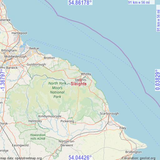
Sleights GPS coordinates[2]
54° 27' 18.216" North, 0° 39' 53.424" West
| Map corner | latitude | longitude |
|---|---|---|
| Upper-left | 54.86178°, | -1.36797° |
| Center: | 54.45506°, | -0.66484° |
| Lower-right: | 54.04426°, | 0.03829° |
| Map W x H: | 90.9×90.9 km | = 56.5×56.5mi |
| max Lat: | 60.39635° ⇑18.4% North |
| Sleights: | 54.45506° |
| min Lat: | ⇓81.6% South 34.60088° |
| min Long | Sleights | max Long |
| -7.64133° | -0.66484° | 32.95536° |
| W 73.1%⇐ | ⇒26.9% E |
Elevation
Elevation of Sleights is 60 m = 197 ft, and this is 12.9 m = 42 ft below average elevation for this country.
| Max E: |
515 m = 1690 ft | 50.4% |
| Avg. | 72.9 m = 239 ft | |
| Sleights | 60 m = 197 ft | |
Min E: |
-30 m = -98 ft | 49.6% |
See also: United Kingdom elevation on elevation.city.
Geographical zone
Sleights is located in North temperate zone (between Tropic of Cancer and the Arctic Circle). Distance of this North polar circle is 1346.3 km =836.6 mi to North.| Distance of | km | miles | from Sleights |
|---|---|---|---|
| North Pole | 3952.2 | 2455.8 | to North |
| Arctic Circle | 1346.3 | 836.6 | to North |
| Tropic Cancer | 3448.9 | 2143 | to South |
| Equator | 6054.8 | 3762.3 | to South |


Nearby cities:
15 places around Sleights: (largest is in red/bold)
• Boosbeck
22.6 km =14 mi,  295°
295°
• Brotton
21.6 km =13.4 mi, 304°
• Burniston
20.2 km =12.6 mi,  136°
136°
• Cloughton
19.1 km =11.9 mi,  132°
132°
• Danby
15.9 km =9.9 mi,  274°
274°
• Easington
16.2 km =10.1 mi,  312°
312°
• Hinderwell
11.6 km =7.2 mi,  322°
322°
• Lingdale
21.1 km =13.1 mi, 295°
• Loftus
18.6 km =11.6 mi, 306°
• Pickering
23.7 km =14.7 mi,  196°
196°
• Saltburn-by-the-Sea
24.4 km =15.2 mi, 305°
• Skelton
24 km =14.9 mi, 299°
• Skinningrove
19.7 km =12.2 mi, 310°
• Staithes
14.2 km =8.8 mi, 324°
• Whitby
4.9 km =3 mi,  41°
41°
Sources, notices
• [Note1] Compared only with cities in United Kingdom existing in our database
• [Src1] Map data: © OpenStreetMap contributors (CC-BY-SA)
• [Src2] Other city data from geonames.org with taken over terms of usage.
• [Src3] Geographical zone / Annual Mean Temperature by Robert A. Rohde @ Wikipedia
