Sittingbourne geodata
Sittingbourne (England) is a populated place; located in United Kingdom in Europe/London (GMT+1) time zone. With population of 48,948 people, there are 239 cities with bigger population in this country. Compared to other cities in United Kingdom, 82.9% of cities are located further ↑North; 94.5% of cities are located further ←West and 84.7% of cities have higher elevation than Sittingbourne. Note1


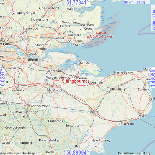
Sittingbourne GPS coordinates[2]
51° 20' 28.608" North, 0° 43' 58.152" East
| Map corner | latitude | longitude |
|---|---|---|
| Upper-left | 51.77841°, | 0.0297° |
| Center: | 51.34128°, | 0.73282° |
| Lower-right: | 50.89994°, | 1.43595° |
| Map W x H: | 97.7×97.7 km | = 60.7×60.7mi |
| max Lat: | 60.39635° ⇑82.9% North |
| Sittingbourne: | 51.34128° |
| min Lat: | ⇓17.1% South 34.60088° |
| min Long | Sittingbourne | max Long |
| -7.64133° | 0.73282° | 32.95536° |
| W 94.5%⇐ | ⇒5.5% E |
Elevation
Elevation of Sittingbourne is 16 m = 52 ft, and this is 56.9 m = 187 ft below average elevation for this country.
| Max E: |
515 m = 1690 ft | 84.7% |
| Avg. | 72.9 m = 239 ft | |
| Sittingbourne | 16 m = 52 ft | |
Min E: |
-30 m = -98 ft | 15.3% |
See also: Sittingbourne elevation on elevation.city.
Geographical zone
Sittingbourne is located in North temperate zone (between Tropic of Cancer and the Arctic Circle). Distance of this North polar circle is 1692.6 km =1051.7 mi to North.| Distance of | km | miles | from Sittingbourne |
|---|---|---|---|
| North Pole | 4298.4 | 2670.9 | to North |
| Arctic Circle | 1692.6 | 1051.7 | to North |
| Tropic Cancer | 3102.7 | 1927.9 | to South |
| Equator | 5708.6 | 3547.2 | to South |


Nearby cities:
15 places around Sittingbourne: (largest is in red/bold)
• Borden
2.4 km =1.5 mi,  250°
250°
• Detling
12.5 km =7.8 mi, 245°
• Eastchurch
11.3 km =7 mi,  49°
49°
• Faversham
11.2 km =7 mi,  105°
105°
• Harrietsham
11.8 km =7.3 mi,  201°
201°
• Iwade
4 km =2.5 mi,  356°
356°
• Lenham
11.6 km =7.2 mi,  184°
184°
• Lower Halstow
5.8 km =3.6 mi,  308°
308°
• Lynsted
4.9 km =3 mi,  130°
130°
• Newington
4.7 km =2.9 mi,  284°
284°
• Queenborough
8.5 km =5.3 mi,  5°
5°
• Rainham
8.9 km =5.5 mi,  285°
285°
• Sheerness
11.2 km =7 mi, 10°
• Teynham
5.2 km =3.2 mi,  103°
103°
• Upchurch
7.1 km =4.4 mi,  303°
303°
Sources, notices
• [Note1] Compared only with cities in United Kingdom existing in our database
• [Src1] Map data: © OpenStreetMap contributors (CC-BY-SA)
• [Src2] Other city data from geonames.org with taken over terms of usage.
• [Src3] Geographical zone / Annual Mean Temperature by Robert A. Rohde @ Wikipedia
