Teynham geodata
Teynham (England) is a populated place; located in United Kingdom in Europe/London (GMT+0) time zone. With population of 2,687 people, there are 2241 cities with bigger population in this country. Compared to other cities in United Kingdom, 83.3% of cities are located further ↑North; 95% of cities are located further ←West and 87% of cities have higher elevation than Teynham. Note1


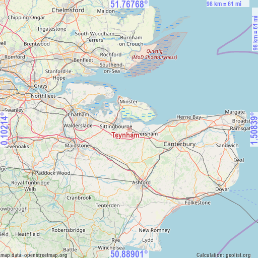
Teynham GPS coordinates[2]
51° 19' 49.62" North, 0° 48' 18.936" East
| Map corner | latitude | longitude |
|---|---|---|
| Upper-left | 51.76768°, | 0.10214° |
| Center: | 51.33045°, | 0.80526° |
| Lower-right: | 50.88901°, | 1.50839° |
| Map W x H: | 97.7×97.7 km | = 60.7×60.7mi |
| max Lat: | 60.39635° ⇑83.3% North |
| Teynham: | 51.33045° |
| min Lat: | ⇓16.7% South 34.60088° |
| min Long | Teynham | max Long |
| -7.64133° | 0.80526° | 32.95536° |
| W 95%⇐ | ⇒5% E |
Elevation
Elevation of Teynham is 14 m = 46 ft, and this is 58.9 m = 193 ft below average elevation for this country.
| Max E: |
515 m = 1690 ft | 87% |
| Avg. | 72.9 m = 239 ft | |
| Teynham | 14 m = 46 ft | |
Min E: |
-30 m = -98 ft | 13% |
See also: United Kingdom elevation on elevation.city.
Geographical zone
Teynham is located in North temperate zone (between Tropic of Cancer and the Arctic Circle). Distance of this North polar circle is 1693.8 km =1052.5 mi to North.| Distance of | km | miles | from Teynham |
|---|---|---|---|
| North Pole | 4299.7 | 2671.7 | to North |
| Arctic Circle | 1693.8 | 1052.5 | to North |
| Tropic Cancer | 3101.5 | 1927.2 | to South |
| Equator | 5707.4 | 3546.4 | to South |


Nearby cities:
15 places around Teynham: (largest is in red/bold)
• Borden
7.3 km =4.5 mi,  273°
273°
• Charing
13.3 km =8.3 mi,  183°
183°
• Eastchurch
9.2 km =5.7 mi,  23°
23°
• Faversham
6 km =3.7 mi,  106°
106°
• Harrietsham
13.5 km =8.4 mi,  223°
223°
• Iwade
7.4 km =4.6 mi,  314°
314°
• Lenham
12 km =7.5 mi,  210°
210°
• Leysdown-on-Sea
11 km =6.8 mi,  47°
47°
• Lower Halstow
10.7 km =6.6 mi,  296°
296°
• Lynsted
2.4 km =1.5 mi, 212°
• Newington
9.9 km =6.2 mi,  284°
284°
• Queenborough
10.6 km =6.6 mi,  336°
336°
• Sheerness
12.6 km =7.8 mi,  346°
346°
• Sittingbourne
5.2 km =3.2 mi, 283°
• Upchurch
12.1 km =7.5 mi,  294°
294°
Sources, notices
• [Note1] Compared only with cities in United Kingdom existing in our database
• [Src1] Map data: © OpenStreetMap contributors (CC-BY-SA)
• [Src2] Other city data from geonames.org with taken over terms of usage.
• [Src3] Geographical zone / Annual Mean Temperature by Robert A. Rohde @ Wikipedia
