Rothwell geodata
Rothwell (England) is a populated place; located in United Kingdom in Europe/London (GMT+1) time zone. With population of 7,694 people, there are 1262 cities with bigger population in this country. Compared to other cities in United Kingdom, 51.4% of cities are located further ↑North; 70.3% of cities are located further ←West and 72.7% of cities have lower elevation than Rothwell. Note1
Administrative division(s):
- Level 1: England
- Level 2: Northamptonshire
- Level 3: Kettering District
- Level 4: Rothwell


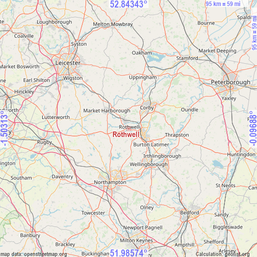
Rothwell GPS coordinates[2]
52° 25' 0.012" North, 0° 48' 0" West
| Map corner | latitude | longitude |
|---|---|---|
| Upper-left | 52.84343°, | -1.50313° |
| Center: | 52.41667°, | -0.8° |
| Lower-right: | 51.98574°, | -0.09688° |
| Map W x H: | 95.4×95.4 km | = 59.3×59.3mi |
| max Lat: | 60.39635° ⇑51.4% North |
| Rothwell: | 52.41667° |
| min Lat: | ⇓48.6% South 34.60088° |
| min Long | Rothwell | max Long |
| -7.64133° | -0.8° | 32.95536° |
| W 70.3%⇐ | ⇒29.7% E |
Elevation
Elevation of Rothwell is 101 m = 331 ft, and this is 28.1 m = 92 ft above average elevation for this country.
| Max E: |
515 m = 1690 ft | 27.3% |
| Rothwell | 101 m 331 ft | |
| Avg. | 72.9 m = 239 ft | |
Min E: |
-30 m = -98 ft | 72.7% |
See also: United Kingdom elevation on elevation.city.
Geographical zone
Rothwell is located in North temperate zone (between Tropic of Cancer and the Arctic Circle). Distance of this North polar circle is 1573 km =977.4 mi to North.| Distance of | km | miles | from Rothwell |
|---|---|---|---|
| North Pole | 4178.9 | 2596.6 | to North |
| Arctic Circle | 1573 | 977.4 | to North |
| Tropic Cancer | 3222.3 | 2002.2 | to South |
| Equator | 5828.2 | 3621.5 | to South |


Nearby cities:
15 places around Rothwell: (largest is in red/bold)
• Brixworth
12 km =7.5 mi,  215°
215°
• Broughton
5.1 km =3.2 mi,  160°
160°
• Burton Latimer
10.1 km =6.3 mi,  125°
125°
• Clipston
10.6 km =6.6 mi,  277°
277°
• Corby
11.6 km =7.2 mi,  40°
40°
• Cottingham
10 km =6.2 mi,  17°
17°
• Desborough
3.1 km =1.9 mi,  332°
332°
• Geddington
7.8 km =4.8 mi,  72°
72°
• Isham
9.3 km =5.8 mi,  135°
135°
• Kettering
5.4 km =3.4 mi,  111°
111°
• Loddington
2.2 km =1.4 mi,  183°
183°
• Market Harborough
10.6 km =6.6 mi,  309°
309°
• Stanion
11.7 km =7.3 mi,  56°
56°
• Walgrave
8.6 km =5.3 mi,  191°
191°
• Wilbarston
7.8 km =4.8 mi,  358°
358°
Sources, notices
• [Note1] Compared only with cities in United Kingdom existing in our database
• [Src1] Map data: © OpenStreetMap contributors (CC-BY-SA)
• [Src2] Other city data from geonames.org with taken over terms of usage.
• [Src3] Geographical zone / Annual Mean Temperature by Robert A. Rohde @ Wikipedia
