Kettering geodata
Kettering (England) is a populated place; located in United Kingdom in Europe/London (GMT+1) time zone. With population of 63,675 people, there are 169 cities with bigger population in this country. Compared to other cities in United Kingdom, 51.7% of cities are located further ↑North; 71.7% of cities are located further ←West and 69.8% of cities have lower elevation than Kettering. Note1


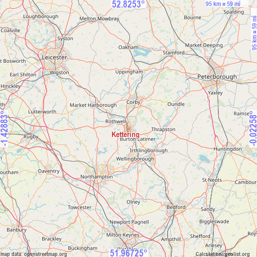
Kettering GPS coordinates[2]
52° 23' 54.096" North, 0° 43' 32.556" West
| Map corner | latitude | longitude |
|---|---|---|
| Upper-left | 52.8253°, | -1.42883° |
| Center: | 52.39836°, | -0.72571° |
| Lower-right: | 51.96725°, | -0.02258° |
| Map W x H: | 95.4×95.4 km | = 59.3×59.3mi |
| max Lat: | 60.39635° ⇑51.7% North |
| Kettering: | 52.39836° |
| min Lat: | ⇓48.3% South 34.60088° |
| min Long | Kettering | max Long |
| -7.64133° | -0.72571° | 32.95536° |
| W 71.7%⇐ | ⇒28.3% E |
Elevation
Elevation of Kettering is 95 m = 312 ft, and this is 22.1 m = 73 ft above average elevation for this country.
| Max E: |
515 m = 1690 ft | 30.2% |
| Kettering | 95 m 312 ft | |
| Avg. | 72.9 m = 239 ft | |
Min E: |
-30 m = -98 ft | 69.8% |
See also: Kettering elevation on elevation.city.
Geographical zone
Kettering is located in North temperate zone (between Tropic of Cancer and the Arctic Circle). Distance of this North polar circle is 1575 km =978.7 mi to North.| Distance of | km | miles | from Kettering |
|---|---|---|---|
| North Pole | 4180.9 | 2597.9 | to North |
| Arctic Circle | 1575 | 978.7 | to North |
| Tropic Cancer | 3220.2 | 2000.9 | to South |
| Equator | 5826.2 | 3620.2 | to South |


Nearby cities:
15 places around Kettering: (largest is in red/bold)
• Brigstock
10.3 km =6.4 mi,  50°
50°
• Broughton
4.3 km =2.7 mi,  230°
230°
• Burton Latimer
5 km =3.1 mi,  140°
140°
• Desborough
8.1 km =5 mi,  306°
306°
• Finedon
8.3 km =5.2 mi, 142°
• Geddington
5 km =3.1 mi,  29°
29°
• Irthlingborough
11.1 km =6.9 mi, 135°
• Isham
4.8 km =3 mi,  161°
161°
• Loddington
5.2 km =3.2 mi,  268°
268°
• Rothwell
5.4 km =3.4 mi,  291°
291°
• Stanion
9.7 km =6 mi, 29°
• Walgrave
9.3 km =5.8 mi, 226°
• Wellingborough
10.8 km =6.7 mi,  168°
168°
• Wilbarston
11.1 km =6.9 mi,  331°
331°
• Woodford
10 km =6.2 mi,  100°
100°
Sources, notices
• [Note1] Compared only with cities in United Kingdom existing in our database
• [Src1] Map data: © OpenStreetMap contributors (CC-BY-SA)
• [Src2] Other city data from geonames.org with taken over terms of usage.
• [Src3] Geographical zone / Annual Mean Temperature by Robert A. Rohde @ Wikipedia
