Ringwood geodata
Ringwood (England) is a populated place; located in United Kingdom in Europe/London (GMT+1) time zone. With population of 14,084 people, there are 814 cities with bigger population in this country. Compared to other cities in United Kingdom, 94.4% of cities are located further ↑North; 50.9% of cities are located further →East and 84.7% of cities have higher elevation than Ringwood. Note1
Administrative division(s):
- Level 1: England
- Level 2: Hampshire
- Level 3: New Forest
- Level 4: Ringwood


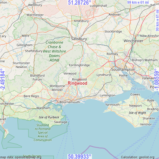
Ringwood GPS coordinates[2]
50° 50' 43.476" North, 1° 47' 19.356" West
| Map corner | latitude | longitude |
|---|---|---|
| Upper-left | 51.28726°, | -2.49184° |
| Center: | 50.84541°, | -1.78871° |
| Lower-right: | 50.39933°, | -1.08559° |
| Map W x H: | 98.7×98.7 km | = 61.3×61.3mi |
| max Lat: | 60.39635° ⇑94.4% North |
| Ringwood: | 50.84541° |
| min Lat: | ⇓5.6% South 34.60088° |
| min Long | Ringwood | max Long |
| -7.64133° | -1.78871° | 32.95536° |
| W 49.1%⇐ | ⇒50.9% E |
Elevation
Elevation of Ringwood is 16 m = 52 ft, and this is 56.9 m = 187 ft below average elevation for this country.
| Max E: |
515 m = 1690 ft | 84.7% |
| Avg. | 72.9 m = 239 ft | |
| Ringwood | 16 m = 52 ft | |
Min E: |
-30 m = -98 ft | 15.3% |
See also: United Kingdom elevation on elevation.city.
Geographical zone
Ringwood is located in North temperate zone (between Tropic of Cancer and the Arctic Circle). Distance of this North polar circle is 1747.7 km =1086 mi to North.| Distance of | km | miles | from Ringwood |
|---|---|---|---|
| North Pole | 4353.6 | 2705.2 | to North |
| Arctic Circle | 1747.7 | 1086 | to North |
| Tropic Cancer | 3047.6 | 1893.7 | to South |
| Equator | 5653.5 | 3512.9 | to South |


Nearby cities:
15 places around Ringwood: (largest is in red/bold)
• Alderholt
8 km =5 mi,  338°
338°
• Bournemouth
15.3 km =9.5 mi,  204°
204°
• Bransgore
8 km =5 mi,  153°
153°
• Burley
6.5 km =4 mi,  107°
107°
• Christchurch
12.2 km =7.6 mi,  177°
177°
• Cranborne
12.4 km =7.7 mi,  311°
311°
• Ferndown
8.9 km =5.5 mi,  241°
241°
• Fordingbridge
9.1 km =5.7 mi,  359°
359°
• Lyndhurst
15.2 km =9.4 mi,  78°
78°
• New Milton
13.2 km =8.2 mi,  139°
139°
• St Leonards
4.2 km =2.6 mi,  247°
247°
• Sway
14.6 km =9.1 mi,  116°
116°
• Three Legged Cross
6.7 km =4.2 mi,  274°
274°
• Verwood
6.6 km =4.1 mi,  300°
300°
• Wimborne Minster
15.3 km =9.5 mi, 243°
Sources, notices
• [Note1] Compared only with cities in United Kingdom existing in our database
• [Src1] Map data: © OpenStreetMap contributors (CC-BY-SA)
• [Src2] Other city data from geonames.org with taken over terms of usage.
• [Src3] Geographical zone / Annual Mean Temperature by Robert A. Rohde @ Wikipedia
