Bournemouth geodata
Bournemouth (England) is a seat of a second-order administrative division; located in United Kingdom in Europe/London (GMT+1) time zone. With population of 163,600 people, there are 53 cities with bigger population in this country. Compared to other cities in United Kingdom, 96.3% of cities are located further ↑North; 52.5% of cities are located further →East and 82% of cities have higher elevation than Bournemouth. Note1


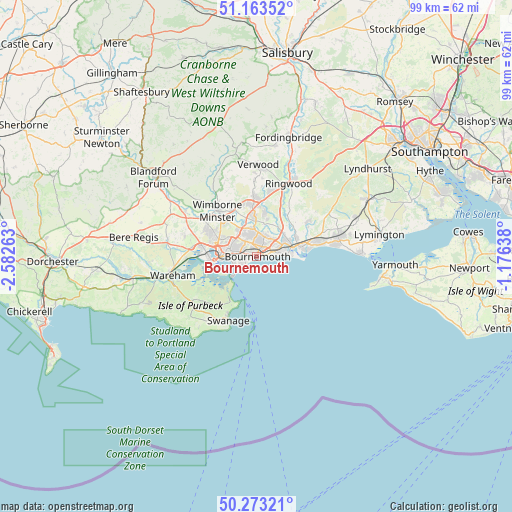
Bournemouth GPS coordinates[2]
50° 43' 13.728" North, 1° 52' 46.2" West
| Map corner | latitude | longitude |
|---|---|---|
| Upper-left | 51.16352°, | -2.58263° |
| Center: | 50.72048°, | -1.8795° |
| Lower-right: | 50.27321°, | -1.17638° |
| Map W x H: | 99×99 km | = 61.5×61.5mi |
| max Lat: | 60.39635° ⇑96.3% North |
| Bournemouth: | 50.72048° |
| min Lat: | ⇓3.7% South 34.60088° |
| min Long | Bournemouth | max Long |
| -7.64133° | -1.8795° | 32.95536° |
| W 47.5%⇐ | ⇒52.5% E |
Elevation
Elevation of Bournemouth is 19 m = 62 ft, and this is 53.9 m = 177 ft below average elevation for this country.
| Max E: |
515 m = 1690 ft | 82% |
| Avg. | 72.9 m = 239 ft | |
| Bournemouth | 19 m = 62 ft | |
Min E: |
-30 m = -98 ft | 18% |
See also: Bournemouth elevation on elevation.city.
Geographical zone
Bournemouth is located in North temperate zone (between Tropic of Cancer and the Arctic Circle). Distance of this North polar circle is 1761.6 km =1094.6 mi to North.| Distance of | km | miles | from Bournemouth |
|---|---|---|---|
| North Pole | 4367.5 | 2713.8 | to North |
| Arctic Circle | 1761.6 | 1094.6 | to North |
| Tropic Cancer | 3033.7 | 1885.1 | to South |
| Equator | 5639.6 | 3504.3 | to South |


Nearby cities:
15 places around Bournemouth: (largest is in red/bold)
• Bransgore
12.1 km =7.5 mi,  55°
55°
• Broadstone
9 km =5.6 mi,  296°
296°
• Canford Heath
7.1 km =4.4 mi, 298°
• Christchurch
7.1 km =4.4 mi,  76°
76°
• Corfe Castle
15.4 km =9.6 mi,  234°
234°
• Ferndown
9.8 km =6.1 mi,  351°
351°
• Lytchett Matravers
14.6 km =9.1 mi,  286°
286°
• New Milton
15.5 km =9.6 mi, 75°
• Parkstone
4.7 km =2.9 mi,  282°
282°
• Poole
7.4 km =4.6 mi,  264°
264°
• Ringwood
15.3 km =9.5 mi,  24°
24°
• St Leonards
12.5 km =7.8 mi,  11°
11°
• Swanage
13.7 km =8.5 mi,  205°
205°
• Three Legged Cross
14.4 km =8.9 mi,  358°
358°
• Wimborne Minster
10.1 km =6.3 mi,  313°
313°
Sources, notices
• [Note1] Compared only with cities in United Kingdom existing in our database
• [Src1] Map data: © OpenStreetMap contributors (CC-BY-SA)
• [Src2] Other city data from geonames.org with taken over terms of usage.
• [Src3] Geographical zone / Annual Mean Temperature by Robert A. Rohde @ Wikipedia
