Christchurch geodata
Christchurch (England) is a populated place; located in United Kingdom in Europe/London (GMT+1) time zone. With population of 42,396 people, there are 284 cities with bigger population in this country. Compared to other cities in United Kingdom, 96.1% of cities are located further ↑North; 50.7% of cities are located further →East and 99% of cities have higher elevation than Christchurch. Note1


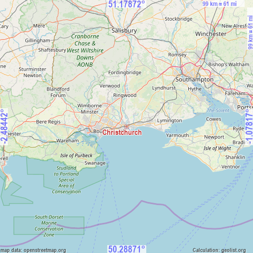
Christchurch GPS coordinates[2]
50° 44' 8.988" North, 1° 46' 52.644" West
| Map corner | latitude | longitude |
|---|---|---|
| Upper-left | 51.17872°, | -2.48442° |
| Center: | 50.73583°, | -1.78129° |
| Lower-right: | 50.28871°, | -1.07817° |
| Map W x H: | 99×99 km | = 61.5×61.5mi |
| max Lat: | 60.39635° ⇑96.1% North |
| Christchurch: | 50.73583° |
| min Lat: | ⇓3.9% South 34.60088° |
| min Long | Christchurch | max Long |
| -7.64133° | -1.78129° | 32.95536° |
| W 49.3%⇐ | ⇒50.7% E |
Elevation
Elevation of Christchurch is 4 m = 13 ft, and this is 68.9 m = 226 ft below average elevation for this country.
| Max E: |
515 m = 1690 ft | 99% |
| Avg. | 72.9 m = 239 ft | |
| Christchurch | 4 m = 13 ft | |
Min E: |
-30 m = -98 ft | 1% |
See also: Christchurch elevation on elevation.city.
Geographical zone
Christchurch is located in North temperate zone (between Tropic of Cancer and the Arctic Circle). Distance of this North polar circle is 1759.9 km =1093.6 mi to North.| Distance of | km | miles | from Christchurch |
|---|---|---|---|
| North Pole | 4365.8 | 2712.8 | to North |
| Arctic Circle | 1759.9 | 1093.6 | to North |
| Tropic Cancer | 3035.4 | 1886.1 | to South |
| Equator | 5641.3 | 3505.3 | to South |


Nearby cities:
15 places around Christchurch: (largest is in red/bold)
• Bournemouth
7.1 km =4.4 mi,  256°
256°
• Bransgore
5.9 km =3.7 mi,  31°
31°
• Broadstone
15.2 km =9.4 mi,  279°
279°
• Burley
11.7 km =7.3 mi, 29°
• Canford Heath
13.3 km =8.3 mi, 277°
• Ferndown
11.5 km =7.1 mi,  313°
313°
• Milford on Sea
13.5 km =8.4 mi,  94°
94°
• New Milton
8.4 km =5.2 mi,  74°
74°
• Parkstone
11.5 km =7.1 mi,  266°
266°
• Poole
14.5 km =9 mi, 260°
• Ringwood
12.2 km =7.6 mi,  357°
357°
• St Leonards
11.4 km =7.1 mi,  337°
337°
• Sway
13.8 km =8.6 mi, 65°
• Three Legged Cross
14.6 km =9.1 mi,  330°
330°
• Wimborne Minster
15.2 km =9.4 mi,  290°
290°
Sources, notices
• [Note1] Compared only with cities in United Kingdom existing in our database
• [Src1] Map data: © OpenStreetMap contributors (CC-BY-SA)
• [Src2] Other city data from geonames.org with taken over terms of usage.
• [Src3] Geographical zone / Annual Mean Temperature by Robert A. Rohde @ Wikipedia
