Reigate geodata
Reigate (England) is a populated place; located in United Kingdom in Europe/London (GMT+1) time zone. With population of 52,123 people, there are 221 cities with bigger population in this country. Compared to other cities in United Kingdom, 85.8% of cities are located further ↑North; 82.8% of cities are located further ←West and 64.5% of cities have lower elevation than Reigate. Note1


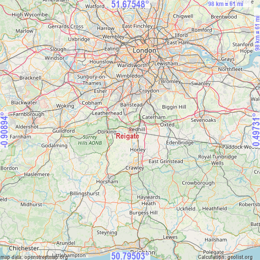
Reigate GPS coordinates[2]
51° 14' 14.496" North, 0° 12' 20.952" West
| Map corner | latitude | longitude |
|---|---|---|
| Upper-left | 51.67548°, | -0.90894° |
| Center: | 51.23736°, | -0.20582° |
| Lower-right: | 50.79503°, | 0.49731° |
| Map W x H: | 97.9×97.9 km | = 60.8×60.8mi |
| max Lat: | 60.39635° ⇑85.8% North |
| Reigate: | 51.23736° |
| min Lat: | ⇓14.2% South 34.60088° |
| min Long | Reigate | max Long |
| -7.64133° | -0.20582° | 32.95536° |
| W 82.8%⇐ | ⇒17.2% E |
Elevation
Elevation of Reigate is 85 m = 279 ft, and this is 12.1 m = 40 ft above average elevation for this country.
| Max E: |
515 m = 1690 ft | 35.5% |
| Reigate | 85 m 279 ft | |
| Avg. | 72.9 m = 239 ft | |
Min E: |
-30 m = -98 ft | 64.5% |
See also: Reigate elevation on elevation.city.
Geographical zone
Reigate is located in North temperate zone (between Tropic of Cancer and the Arctic Circle). Distance of this North polar circle is 1704.1 km =1058.9 mi to North.| Distance of | km | miles | from Reigate |
|---|---|---|---|
| North Pole | 4310 | 2678.1 | to North |
| Arctic Circle | 1704.1 | 1058.9 | to North |
| Tropic Cancer | 3091.1 | 1920.7 | to South |
| Equator | 5697.1 | 3540 | to South |


Nearby cities:
15 places around Reigate: (largest is in red/bold)
• Banstead
9.4 km =5.8 mi,  359°
359°
• Betchworth
4.2 km =2.6 mi,  264°
264°
• Bletchingley
7.3 km =4.5 mi,  87°
87°
• Caterham
10.1 km =6.3 mi,  60°
60°
• Charlwood
9.1 km =5.7 mi,  188°
188°
• Dorking
8.9 km =5.5 mi,  266°
266°
• Godstone
9.6 km =6 mi,  83°
83°
• Headley
6.9 km =4.3 mi,  314°
314°
• Horley
7.7 km =4.8 mi,  155°
155°
• Lower Kingswood
3.6 km =2.2 mi,  352°
352°
• Mickleham
9 km =5.6 mi,  290°
290°
• Newdigate
9.9 km =6.2 mi,  217°
217°
• Redhill
2.5 km =1.6 mi, 81°
• Salfords
4.5 km =2.8 mi,  145°
145°
• Tadworth
6.4 km =4 mi,  340°
340°
Sources, notices
• [Note1] Compared only with cities in United Kingdom existing in our database
• [Src1] Map data: © OpenStreetMap contributors (CC-BY-SA)
• [Src2] Other city data from geonames.org with taken over terms of usage.
• [Src3] Geographical zone / Annual Mean Temperature by Robert A. Rohde @ Wikipedia
