Redhill geodata
Redhill (England) is a populated place; located in United Kingdom in Europe/London (GMT+1) time zone. With population of 51,559 people, there are 225 cities with bigger population in this country. Compared to other cities in United Kingdom, 85.7% of cities are located further ↑North; 83.5% of cities are located further ←West and 66.5% of cities have lower elevation than Redhill. Note1


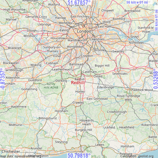
Redhill GPS coordinates[2]
51° 14' 25.728" North, 0° 10' 13.584" West
| Map corner | latitude | longitude |
|---|---|---|
| Upper-left | 51.67857°, | -0.87357° |
| Center: | 51.24048°, | -0.17044° |
| Lower-right: | 50.79818°, | 0.53268° |
| Map W x H: | 97.9×97.9 km | = 60.8×60.8mi |
| max Lat: | 60.39635° ⇑85.7% North |
| Redhill: | 51.24048° |
| min Lat: | ⇓14.3% South 34.60088° |
| min Long | Redhill | max Long |
| -7.64133° | -0.17044° | 32.95536° |
| W 83.5%⇐ | ⇒16.5% E |
Elevation
Elevation of Redhill is 89 m = 292 ft, and this is 16.1 m = 53 ft above average elevation for this country.
| Max E: |
515 m = 1690 ft | 33.5% |
| Redhill | 89 m 292 ft | |
| Avg. | 72.9 m = 239 ft | |
Min E: |
-30 m = -98 ft | 66.5% |
See also: Redhill elevation on elevation.city.
Geographical zone
Redhill is located in North temperate zone (between Tropic of Cancer and the Arctic Circle). Distance of this North polar circle is 1703.8 km =1058.7 mi to North.| Distance of | km | miles | from Redhill |
|---|---|---|---|
| North Pole | 4309.7 | 2677.9 | to North |
| Arctic Circle | 1703.8 | 1058.7 | to North |
| Tropic Cancer | 3091.5 | 1921 | to South |
| Equator | 5697.4 | 3540.2 | to South |


Nearby cities:
15 places around Redhill: (largest is in red/bold)
• Banstead
9.4 km =5.8 mi,  344°
344°
• Betchworth
6.7 km =4.2 mi,  263°
263°
• Bletchingley
4.9 km =3 mi,  89°
89°
• Blindley Heath
9.8 km =6.1 mi,  122°
122°
• Caterham
7.9 km =4.9 mi,  53°
53°
• Charlwood
10.1 km =6.3 mi,  202°
202°
• Coulsdon
9.1 km =5.7 mi,  13°
13°
• Godstone
7.1 km =4.4 mi,  83°
83°
• Headley
8.7 km =5.4 mi,  301°
301°
• Horley
7.4 km =4.6 mi,  173°
173°
• Lower Kingswood
4.4 km =2.7 mi,  318°
318°
• Reigate
2.5 km =1.6 mi, 261°
• Salfords
4 km =2.5 mi,  179°
179°
• Tadworth
7.3 km =4.5 mi, 321°
• Whyteleafe
9.6 km =6 mi,  38°
38°
Sources, notices
• [Note1] Compared only with cities in United Kingdom existing in our database
• [Src1] Map data: © OpenStreetMap contributors (CC-BY-SA)
• [Src2] Other city data from geonames.org with taken over terms of usage.
• [Src3] Geographical zone / Annual Mean Temperature by Robert A. Rohde @ Wikipedia
