Banstead geodata
Banstead (England) is a populated place; located in United Kingdom in Europe/London (GMT+1) time zone. With population of 46,280 people, there are 255 cities with bigger population in this country. Compared to other cities in United Kingdom, 83.6% of cities are located further ↑North; 82.8% of cities are located further ←West and 91.8% of cities have lower elevation than Banstead. Note1


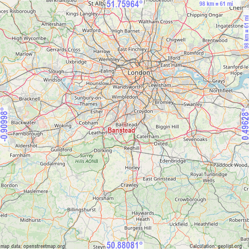
Banstead GPS coordinates[2]
51° 19' 20.388" North, 0° 12' 24.66" West
| Map corner | latitude | longitude |
|---|---|---|
| Upper-left | 51.75964°, | -0.90998° |
| Center: | 51.32233°, | -0.20685° |
| Lower-right: | 50.88081°, | 0.49628° |
| Map W x H: | 97.7×97.7 km | = 60.7×60.7mi |
| max Lat: | 60.39635° ⇑83.6% North |
| Banstead: | 51.32233° |
| min Lat: | ⇓16.4% South 34.60088° |
| min Long | Banstead | max Long |
| -7.64133° | -0.20685° | 32.95536° |
| W 82.8%⇐ | ⇒17.2% E |
Elevation
Elevation of Banstead is 160 m = 525 ft, and this is 87.1 m = 286 ft above average elevation for this country.
| Max E: |
515 m = 1690 ft | 8.2% |
| Banstead | 160 m 525 ft | |
| Avg. | 72.9 m = 239 ft | |
Min E: |
-30 m = -98 ft | 91.8% |
See also: Banstead elevation on elevation.city.
Geographical zone
Banstead is located in North temperate zone (between Tropic of Cancer and the Arctic Circle). Distance of this North polar circle is 1694.7 km =1053 mi to North.| Distance of | km | miles | from Banstead |
|---|---|---|---|
| North Pole | 4300.6 | 2672.3 | to North |
| Arctic Circle | 1694.7 | 1053 | to North |
| Tropic Cancer | 3100.6 | 1926.6 | to South |
| Equator | 5706.5 | 3545.9 | to South |


Nearby cities:
15 places around Banstead: (largest is in red/bold)
• Ashtead
6.6 km =4.1 mi,  256°
256°
• Carshalton
5.8 km =3.6 mi,  28°
28°
• Cheam
4.5 km =2.8 mi,  348°
348°
• Chessington
8.1 km =5 mi,  303°
303°
• Coulsdon
4.6 km =2.9 mi,  93°
93°
• Epsom
4.5 km =2.8 mi,  281°
281°
• Ewell
4.2 km =2.6 mi,  315°
315°
• Headley
6.7 km =4.2 mi,  226°
226°
• Hook
8.6 km =5.3 mi,  306°
306°
• Lower Kingswood
5.9 km =3.7 mi,  183°
183°
• Morden
8.5 km =5.3 mi,  3°
3°
• Purley
6.8 km =4.2 mi,  76°
76°
• Sutton
3.1 km =1.9 mi,  8°
8°
• Tadworth
4 km =2.5 mi,  210°
210°
• Worcester Park
6.9 km =4.3 mi,  337°
337°
Sources, notices
• [Note1] Compared only with cities in United Kingdom existing in our database
• [Src1] Map data: © OpenStreetMap contributors (CC-BY-SA)
• [Src2] Other city data from geonames.org with taken over terms of usage.
• [Src3] Geographical zone / Annual Mean Temperature by Robert A. Rohde @ Wikipedia
