Rathfriland geodata
Rathfriland (Northern Ireland) is a populated place; located in United Kingdom in Europe/London (GMT+1) time zone. With population of 2,063 people, there are 2588 cities with bigger population in this country. Compared to other cities in United Kingdom, 80.5% of cities are located further ↓South; 98.6% of cities are located further →East and 64% of cities have lower elevation than Rathfriland. Note1


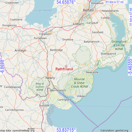
Rathfriland GPS coordinates[2]
54° 15' 0" North, 6° 10' 0.012" West
| Map corner | latitude | longitude |
|---|---|---|
| Upper-left | 54.65876°, | -6.8698° |
| Center: | 54.25°, | -6.16667° |
| Lower-right: | 53.83715°, | -5.46355° |
| Map W x H: | 91.4×91.4 km | = 56.8×56.8mi |
| max Lat: | 60.39635° ⇑19.5% North |
| Rathfriland: | 54.25° |
| min Lat: | ⇓80.5% South 34.60088° |
| min Long | Rathfriland | max Long |
| -7.64133° | -6.16667° | 32.95536° |
| W 1.4%⇐ | ⇒98.6% E |
Elevation
Elevation of Rathfriland is 84 m = 276 ft, and this is 11.1 m = 36 ft above average elevation for this country.
| Max E: |
515 m = 1690 ft | 36% |
| Rathfriland | 84 m 276 ft | |
| Avg. | 72.9 m = 239 ft | |
Min E: |
-30 m = -98 ft | 64% |
See also: United Kingdom elevation on elevation.city.
Geographical zone
Rathfriland is located in North temperate zone (between Tropic of Cancer and the Arctic Circle). Distance of this North polar circle is 1369.1 km =850.7 mi to North.| Distance of | km | miles | from Rathfriland |
|---|---|---|---|
| North Pole | 3975 | 2469.9 | to North |
| Arctic Circle | 1369.1 | 850.7 | to North |
| Tropic Cancer | 3426.1 | 2128.9 | to South |
| Equator | 6032 | 3748.1 | to South |


Nearby cities:
15 places around Rathfriland: (largest is in red/bold)
• Annahilt
23.1 km =14.4 mi,  27°
27°
• Annalong
23.5 km =14.6 mi,  132°
132°
• Ballynahinch
24.3 km =15.1 mi,  45°
45°
• Banbridge
13.5 km =8.4 mi,  325°
325°
• Castlewellan
14.5 km =9 mi,  86°
86°
• Dundrum
20.9 km =13 mi, 87°
• Gilford
18.6 km =11.6 mi,  317°
317°
• Hillsborough
24.4 km =15.2 mi,  13°
13°
• Kilkeel
23.5 km =14.6 mi,  153°
153°
• Newcastle
18.3 km =11.4 mi,  101°
101°
• Newry
13.7 km =8.5 mi,  234°
234°
• Rostrevor
16.8 km =10.4 mi,  187°
187°
• Tandragee
19.8 km =12.3 mi,  306°
306°
• Waringstown
22.2 km =13.8 mi,  337°
337°
• Warrenpoint
17.5 km =10.9 mi,  199°
199°
Sources, notices
• [Note1] Compared only with cities in United Kingdom existing in our database
• [Src1] Map data: © OpenStreetMap contributors (CC-BY-SA)
• [Src2] Other city data from geonames.org with taken over terms of usage.
• [Src3] Geographical zone / Annual Mean Temperature by Robert A. Rohde @ Wikipedia
