Newry geodata
Newry (Northern Ireland) is a seat of a second-order administrative division; located in United Kingdom in Europe/London (GMT+1) time zone. With population of 27,757 people, there are 434 cities with bigger population in this country. Compared to other cities in United Kingdom, 80% of cities are located further ↓South; 99% of cities are located further →East and 97.5% of cities have higher elevation than Newry. Note1


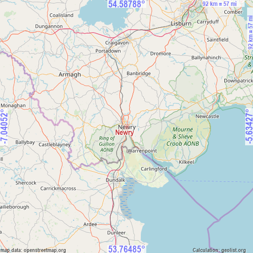
Newry GPS coordinates[2]
54° 10' 42.276" North, 6° 20' 14.604" West
| Map corner | latitude | longitude |
|---|---|---|
| Upper-left | 54.58788°, | -7.04052° |
| Center: | 54.17841°, | -6.33739° |
| Lower-right: | 53.76485°, | -5.63427° |
| Map W x H: | 91.5×91.5 km | = 56.9×56.9mi |
| max Lat: | 60.39635° ⇑20% North |
| Newry: | 54.17841° |
| min Lat: | ⇓80% South 34.60088° |
| min Long | Newry | max Long |
| -7.64133° | -6.33739° | 32.95536° |
| W 1%⇐ | ⇒99% E |
Elevation
Elevation of Newry is 6 m = 20 ft, and this is 66.9 m = 219 ft below average elevation for this country.
| Max E: |
515 m = 1690 ft | 97.5% |
| Avg. | 72.9 m = 239 ft | |
| Newry | 6 m = 20 ft | |
Min E: |
-30 m = -98 ft | 2.5% |
See also: United Kingdom elevation on elevation.city.
Geographical zone
Newry is located in North temperate zone (between Tropic of Cancer and the Arctic Circle). Distance of this North polar circle is 1377.1 km =855.7 mi to North.| Distance of | km | miles | from Newry |
|---|---|---|---|
| North Pole | 3983 | 2474.9 | to North |
| Arctic Circle | 1377.1 | 855.7 | to North |
| Tropic Cancer | 3418.2 | 2124 | to South |
| Equator | 6024.1 | 3743.2 | to South |


Nearby cities:
15 places around Newry: (largest is in red/bold)
• Annalong
29.6 km =18.4 mi,  105°
105°
• Armagh
28.7 km =17.8 mi,  311°
311°
• Banbridge
19.4 km =12.1 mi,  10°
10°
• Castlewellan
27 km =16.8 mi,  71°
71°
• Crossmaglen
20.1 km =12.5 mi,  238°
238°
• Gilford
21.6 km =13.4 mi,  355°
355°
• Keady
24.9 km =15.5 mi,  288°
288°
• Kilkeel
25.3 km =15.7 mi,  120°
120°
• Newcastle
29.4 km =18.3 mi,  81°
81°
• Portadown
28.1 km =17.5 mi,  345°
345°
• Rathfriland
13.7 km =8.5 mi,  54°
54°
• Rostrevor
12.5 km =7.8 mi,  134°
134°
• Tandragee
20.2 km =12.6 mi, 345°
• Waringstown
28.6 km =17.8 mi,  4°
4°
• Warrenpoint
10 km =6.2 mi,  148°
148°
Sources, notices
• [Note1] Compared only with cities in United Kingdom existing in our database
• [Src1] Map data: © OpenStreetMap contributors (CC-BY-SA)
• [Src2] Other city data from geonames.org with taken over terms of usage.
• [Src3] Geographical zone / Annual Mean Temperature by Robert A. Rohde @ Wikipedia
