Kilkeel geodata
Kilkeel (Northern Ireland) is a populated place; located in United Kingdom in Europe/London (GMT+1) time zone. With population of 6,447 people, there are 1400 cities with bigger population in this country. Compared to other cities in United Kingdom, 79% of cities are located further ↓South; 98.4% of cities are located further →East and 84.7% of cities have higher elevation than Kilkeel. Note1


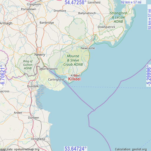
Kilkeel GPS coordinates[2]
54° 3' 43.056" North, 6° 0' 11.088" West
| Map corner | latitude | longitude |
|---|---|---|
| Upper-left | 54.47258°, | -6.70621° |
| Center: | 54.06196°, | -6.00308° |
| Lower-right: | 53.64724°, | -5.29996° |
| Map W x H: | 91.8×91.8 km | = 57×57mi |
| max Lat: | 60.39635° ⇑21% North |
| Kilkeel: | 54.06196° |
| min Lat: | ⇓79% South 34.60088° |
| min Long | Kilkeel | max Long |
| -7.64133° | -6.00308° | 32.95536° |
| W 1.6%⇐ | ⇒98.4% E |
Elevation
Elevation of Kilkeel is 16 m = 52 ft, and this is 56.9 m = 187 ft below average elevation for this country.
| Max E: |
515 m = 1690 ft | 84.7% |
| Avg. | 72.9 m = 239 ft | |
| Kilkeel | 16 m = 52 ft | |
Min E: |
-30 m = -98 ft | 15.3% |
See also: United Kingdom elevation on elevation.city.
Geographical zone
Kilkeel is located in North temperate zone (between Tropic of Cancer and the Arctic Circle). Distance of this North polar circle is 1390 km =863.7 mi to North.| Distance of | km | miles | from Kilkeel |
|---|---|---|---|
| North Pole | 3995.9 | 2482.9 | to North |
| Arctic Circle | 1390 | 863.7 | to North |
| Tropic Cancer | 3405.2 | 2115.9 | to South |
| Equator | 6011.1 | 3735.1 | to South |


Nearby cities:
15 places around Kilkeel: (largest is in red/bold)
• Annahilt
41.3 km =25.7 mi,  0°
0°
• Annalong
8.5 km =5.3 mi,  52°
52°
• Ardglass
34 km =21.1 mi, 48°
• Ballynahinch
38.5 km =23.9 mi,  10°
10°
• Banbridge
36.8 km =22.9 mi,  330°
330°
• Castlewellan
22 km =13.7 mi, 9°
• Crossgar
40.4 km =25.1 mi,  22°
22°
• Crossmaglen
39 km =24.2 mi,  273°
273°
• Downpatrick
35 km =21.7 mi,  32°
32°
• Dundrum
24.1 km =15 mi, 25°
• Newcastle
18.9 km =11.7 mi, 23°
• Newry
25.3 km =15.7 mi,  300°
300°
• Rathfriland
23.5 km =14.6 mi, 333°
• Rostrevor
13.5 km =8.4 mi,  288°
288°
• Warrenpoint
17.2 km =10.7 mi,  284°
284°
Sources, notices
• [Note1] Compared only with cities in United Kingdom existing in our database
• [Src1] Map data: © OpenStreetMap contributors (CC-BY-SA)
• [Src2] Other city data from geonames.org with taken over terms of usage.
• [Src3] Geographical zone / Annual Mean Temperature by Robert A. Rohde @ Wikipedia
