Raskelf geodata
Raskelf (England) is a seat of a fourth-order administrative division; located in United Kingdom in Europe/London (GMT+1) time zone. With population of 519 people, there are 4832 cities with bigger population in this country. Compared to other cities in United Kingdom, 79.6% of cities are located further ↓South; 61.7% of cities are located further ←West and 69.2% of cities have higher elevation than Raskelf. Note1
Administrative division(s):
- Level 1: England
- Level 2: North Yorkshire
- Level 3: Hambleton District
- Level 4: Raskelf


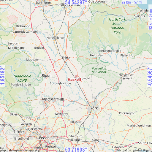
Raskelf GPS coordinates[2]
54° 7' 58.98" North, 1° 14' 55.644" West
| Map corner | latitude | longitude |
|---|---|---|
| Upper-left | 54.54297°, | -1.95192° |
| Center: | 54.13305°, | -1.24879° |
| Lower-right: | 53.71903°, | -0.54567° |
| Map W x H: | 91.6×91.6 km | = 56.9×56.9mi |
| max Lat: | 60.39635° ⇑20.4% North |
| Raskelf: | 54.13305° |
| min Lat: | ⇓79.6% South 34.60088° |
| min Long | Raskelf | max Long |
| -7.64133° | -1.24879° | 32.95536° |
| W 61.7%⇐ | ⇒38.3% E |
Elevation
Elevation of Raskelf is 34 m = 112 ft, and this is 38.9 m = 128 ft below average elevation for this country.
| Max E: |
515 m = 1690 ft | 69.2% |
| Avg. | 72.9 m = 239 ft | |
| Raskelf | 34 m = 112 ft | |
Min E: |
-30 m = -98 ft | 30.8% |
See also: United Kingdom elevation on elevation.city.
Geographical zone
Raskelf is located in North temperate zone (between Tropic of Cancer and the Arctic Circle). Distance of this North polar circle is 1382.1 km =858.8 mi to North.| Distance of | km | miles | from Raskelf |
|---|---|---|---|
| North Pole | 3988 | 2478 | to North |
| Arctic Circle | 1382.1 | 858.8 | to North |
| Tropic Cancer | 3413.1 | 2120.8 | to South |
| Equator | 6019 | 3740 | to South |


Nearby cities:
15 places around Raskelf: (largest is in red/bold)
• Alne
5.5 km =3.4 mi,  174°
174°
• Ampleforth
11.8 km =7.3 mi,  51°
51°
• Angram Grange
6.3 km =3.9 mi,  22°
22°
• Bagby
9.8 km =6.1 mi,  344°
344°
• Boroughbridge
11 km =6.8 mi,  243°
243°
• Dalton
8.6 km =5.3 mi,  310°
310°
• Easingwold
3.9 km =2.4 mi,  111°
111°
• Great Ouseburn
10.2 km =6.3 mi,  205°
205°
• Green Hammerton
14.6 km =9.1 mi,  193°
193°
• Husthwaite
4.8 km =3 mi,  32°
32°
• Linton upon Ouse
9.6 km =6 mi,  180°
180°
• Sheriff Hutton
16.5 km =10.3 mi, 107°
• Skelton
16.6 km =10.3 mi,  153°
153°
• Sutton on the Forest
11.5 km =7.1 mi,  124°
124°
• Thirsk
12.7 km =7.9 mi,  330°
330°
Sources, notices
• [Note1] Compared only with cities in United Kingdom existing in our database
• [Src1] Map data: © OpenStreetMap contributors (CC-BY-SA)
• [Src2] Other city data from geonames.org with taken over terms of usage.
• [Src3] Geographical zone / Annual Mean Temperature by Robert A. Rohde @ Wikipedia
