Bagby geodata
Bagby (England) is a populated place; located in United Kingdom in Europe/London (GMT+1) time zone. With population of 593 people, there are 4601 cities with bigger population in this country. Compared to other cities in United Kingdom, 80.3% of cities are located further ↓South; 60.6% of cities are located further ←West and 54.7% of cities have lower elevation than Bagby. Note1
Administrative division(s):
- Level 1: England
- Level 2: North Yorkshire
- Level 3: Hambleton District
- Level 4: Bagby


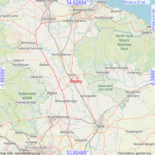
Bagby GPS coordinates[2]
54° 13' 4.296" North, 1° 17' 23.748" West
| Map corner | latitude | longitude |
|---|---|---|
| Upper-left | 54.62694°, | -1.99306° |
| Center: | 54.21786°, | -1.28993° |
| Lower-right: | 53.80469°, | -0.5868° |
| Map W x H: | 91.4×91.4 km | = 56.8×56.8mi |
| max Lat: | 60.39635° ⇑19.7% North |
| Bagby: | 54.21786° |
| min Lat: | ⇓80.3% South 34.60088° |
| min Long | Bagby | max Long |
| -7.64133° | -1.28993° | 32.95536° |
| W 60.6%⇐ | ⇒39.4% E |
Elevation
Elevation of Bagby is 68 m = 223 ft, and this is 4.9 m = 16 ft below average elevation for this country.
| Max E: |
515 m = 1690 ft | 45.3% |
| Avg. | 72.9 m = 239 ft | |
| Bagby | 68 m = 223 ft | |
Min E: |
-30 m = -98 ft | 54.7% |
See also: United Kingdom elevation on elevation.city.
Geographical zone
Bagby is located in North temperate zone (between Tropic of Cancer and the Arctic Circle). Distance of this North polar circle is 1372.7 km =853 mi to North.| Distance of | km | miles | from Bagby |
|---|---|---|---|
| North Pole | 3978.6 | 2472.2 | to North |
| Arctic Circle | 1372.7 | 853 | to North |
| Tropic Cancer | 3422.5 | 2126.6 | to South |
| Equator | 6028.5 | 3745.9 | to South |


Nearby cities:
15 places around Bagby: (largest is in red/bold)
• Alne
15.3 km =9.5 mi,  167°
167°
• Ampleforth
12.1 km =7.5 mi,  99°
99°
• Angram Grange
6.2 km =3.9 mi,  125°
125°
• Boroughbridge
16 km =9.9 mi,  206°
206°
• Brompton
18.1 km =11.2 mi,  331°
331°
• Dalton
5.5 km =3.4 mi,  225°
225°
• Easingwold
12.5 km =7.8 mi,  150°
150°
• Helmsley
15.5 km =9.6 mi,  78°
78°
• Husthwaite
7.5 km =4.7 mi,  135°
135°
• Northallerton
16.3 km =10.1 mi, 325°
• Osmotherley
16.8 km =10.4 mi,  357°
357°
• Raskelf
9.8 km =6.1 mi,  164°
164°
• Ripon
18 km =11.2 mi,  239°
239°
• Sharow
16.4 km =10.2 mi, 238°
• Thirsk
3.9 km =2.4 mi,  295°
295°
Sources, notices
• [Note1] Compared only with cities in United Kingdom existing in our database
• [Src1] Map data: © OpenStreetMap contributors (CC-BY-SA)
• [Src2] Other city data from geonames.org with taken over terms of usage.
• [Src3] Geographical zone / Annual Mean Temperature by Robert A. Rohde @ Wikipedia
