Weymouth geodata
Weymouth (England) is a populated place; located in United Kingdom in Europe/London (GMT+1) time zone. With population of 57,691 people, there are 195 cities with bigger population in this country. Compared to other cities in United Kingdom, 97.4% of cities are located further ↑North; 64.3% of cities are located further →East and 100% of cities have higher elevation than Weymouth. Note1
Administrative division(s):
- Level 1: England
- Level 2: Dorset
- Level 3: Weymouth and Portland District


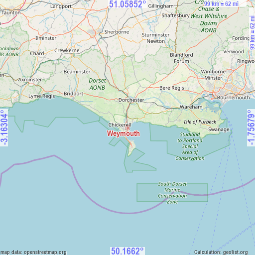
Weymouth GPS coordinates[2]
50° 36' 52.128" North, 2° 27' 35.676" West
| Map corner | latitude | longitude |
|---|---|---|
| Upper-left | 51.05852°, | -3.16304° |
| Center: | 50.61448°, | -2.45991° |
| Lower-right: | 50.1662°, | -1.75679° |
| Map W x H: | 99.2×99.2 km | = 61.6×61.6mi |
| max Lat: | 60.39635° ⇑97.4% North |
| Weymouth: | 50.61448° |
| min Lat: | ⇓2.6% South 34.60088° |
| min Long | Weymouth | max Long |
| -7.64133° | -2.45991° | 32.95536° |
| W 35.7%⇐ | ⇒64.3% E |
Elevation
Elevation of Weymouth is -2 m = -7 ft, and this is 74.9 m = 246 ft below average elevation for this country.
| Max E: |
515 m = 1690 ft | 100% |
| Avg. | 72.9 m = 239 ft | |
| Weymouth | -2 m = -7 ft | |
Min E: |
-30 m = -98 ft | 0% |
See also: Weymouth elevation on elevation.city.
Geographical zone
Weymouth is located in North temperate zone (between Tropic of Cancer and the Arctic Circle). Distance of this North polar circle is 1773.4 km =1101.9 mi to North.| Distance of | km | miles | from Weymouth |
|---|---|---|---|
| North Pole | 4379.3 | 2721.2 | to North |
| Arctic Circle | 1773.4 | 1101.9 | to North |
| Tropic Cancer | 3021.9 | 1877.7 | to South |
| Equator | 5627.8 | 3497 | to South |


Nearby cities:
15 places around Weymouth: (largest is in red/bold)
• Bovington Camp
18.4 km =11.4 mi,  59°
59°
• Burton Bradstock
21.3 km =13.2 mi,  297°
297°
• Cerne Abbas
21.6 km =13.4 mi,  357°
357°
• Charminster
13.2 km =8.2 mi,  3°
3°
• Chickerell
3.2 km =2 mi,  289°
289°
• Dorchester
11.5 km =7.1 mi,  9°
9°
• Easton
9.1 km =5.7 mi,  175°
175°
• Fortuneswell
6.1 km =3.8 mi,  168°
168°
• Maiden Newton
19.9 km =12.4 mi,  336°
336°
• Overcombe
3 km =1.9 mi,  40°
40°
• Portesham
9.6 km =6 mi,  310°
310°
• Portland
5.3 km =3.3 mi, 168°
• Puddletown
16.9 km =10.5 mi,  27°
27°
• Winterbourne Abbas
12.5 km =7.8 mi,  331°
331°
• Wool
18.5 km =11.5 mi,  66°
66°
Sources, notices
• [Note1] Compared only with cities in United Kingdom existing in our database
• [Src1] Map data: © OpenStreetMap contributors (CC-BY-SA)
• [Src2] Other city data from geonames.org with taken over terms of usage.
• [Src3] Geographical zone / Annual Mean Temperature by Robert A. Rohde @ Wikipedia
