Portrush geodata
Portrush (Northern Ireland) is a populated place; located in United Kingdom in Europe/London (GMT+1) time zone. With population of 6,684 people, there are 1364 cities with bigger population in this country. Compared to other cities in United Kingdom, 87.7% of cities are located further ↓South; 99.3% of cities are located further →East and 91.2% of cities have higher elevation than Portrush. Note1


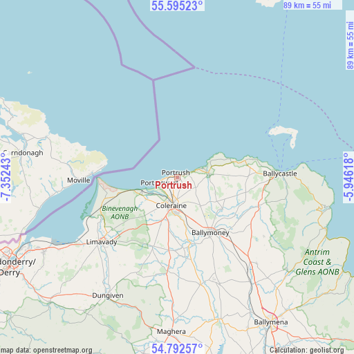
Portrush GPS coordinates[2]
55° 11' 45.312" North, 6° 38' 57.48" West
| Map corner | latitude | longitude |
|---|---|---|
| Upper-left | 55.59523°, | -7.35243° |
| Center: | 55.19592°, | -6.6493° |
| Lower-right: | 54.79257°, | -5.94618° |
| Map W x H: | 89.2×89.2 km | = 55.4×55.4mi |
| max Lat: | 60.39635° ⇑12.3% North |
| Portrush: | 55.19592° |
| min Lat: | ⇓87.7% South 34.60088° |
| min Long | Portrush | max Long |
| -7.64133° | -6.6493° | 32.95536° |
| W 0.7%⇐ | ⇒99.3% E |
Elevation
Elevation of Portrush is 11 m = 36 ft, and this is 61.9 m = 203 ft below average elevation for this country.
| Max E: |
515 m = 1690 ft | 91.2% |
| Avg. | 72.9 m = 239 ft | |
| Portrush | 11 m = 36 ft | |
Min E: |
-30 m = -98 ft | 8.8% |
See also: United Kingdom elevation on elevation.city.
Geographical zone
Portrush is located in North temperate zone (between Tropic of Cancer and the Arctic Circle). Distance of this North polar circle is 1264 km =785.4 mi to North.| Distance of | km | miles | from Portrush |
|---|---|---|---|
| North Pole | 3869.9 | 2404.6 | to North |
| Arctic Circle | 1264 | 785.4 | to North |
| Tropic Cancer | 3531.3 | 2194.2 | to South |
| Equator | 6137.2 | 3813.5 | to South |


Nearby cities:
15 places around Portrush: (largest is in red/bold)
• Ballintoy Harbour
18.6 km =11.6 mi,  73°
73°
• Ballycastle
25.8 km =16 mi,  87°
87°
• Ballykelly
28.9 km =18 mi,  234°
234°
• Ballymoney
16.5 km =10.3 mi,  147°
147°
• Ballypatrick
31.7 km =19.7 mi, 92°
• Bushmills
8.3 km =5.2 mi,  83°
83°
• Castlerock
9.9 km =6.2 mi,  239°
239°
• Coleraine
7 km =4.3 mi,  189°
189°
• Dungiven
33.8 km =21 mi,  210°
210°
• Dunloy
25.5 km =15.8 mi,  143°
143°
• Garvagh
23.7 km =14.7 mi,  182°
182°
• Kilrea
27.9 km =17.3 mi,  167°
167°
• Limavady
25.1 km =15.6 mi, 229°
• Portglenone
37.8 km =23.5 mi,  162°
162°
• Portstewart
4.4 km =2.7 mi,  248°
248°
Sources, notices
• [Note1] Compared only with cities in United Kingdom existing in our database
• [Src1] Map data: © OpenStreetMap contributors (CC-BY-SA)
• [Src2] Other city data from geonames.org with taken over terms of usage.
• [Src3] Geographical zone / Annual Mean Temperature by Robert A. Rohde @ Wikipedia
