Ballymoney geodata
Ballymoney (Northern Ireland) is a seat of a second-order administrative division; located in United Kingdom in Europe/London (GMT+1) time zone. With population of 9,625 people, there are 1088 cities with bigger population in this country. Compared to other cities in United Kingdom, 87.2% of cities are located further ↓South; 99.2% of cities are located further →East and 62.4% of cities have higher elevation than Ballymoney. Note1


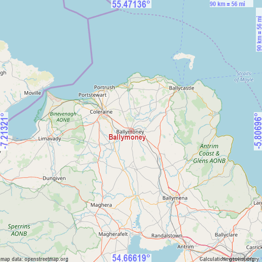
Ballymoney GPS coordinates[2]
55° 4' 14.88" North, 6° 30' 36.324" West
| Map corner | latitude | longitude |
|---|---|---|
| Upper-left | 55.47136°, | -7.21321° |
| Center: | 55.0708°, | -6.51009° |
| Lower-right: | 54.66619°, | -5.80696° |
| Map W x H: | 89.5×89.5 km | = 55.6×55.6mi |
| max Lat: | 60.39635° ⇑12.8% North |
| Ballymoney: | 55.0708° |
| min Lat: | ⇓87.2% South 34.60088° |
| min Long | Ballymoney | max Long |
| -7.64133° | -6.51009° | 32.95536° |
| W 0.8%⇐ | ⇒99.2% E |
Elevation
Elevation of Ballymoney is 43 m = 141 ft, and this is 29.9 m = 98 ft below average elevation for this country.
| Max E: |
515 m = 1690 ft | 62.4% |
| Avg. | 72.9 m = 239 ft | |
| Ballymoney | 43 m = 141 ft | |
Min E: |
-30 m = -98 ft | 37.6% |
See also: United Kingdom elevation on elevation.city.
Geographical zone
Ballymoney is located in North temperate zone (between Tropic of Cancer and the Arctic Circle). Distance of this North polar circle is 1277.9 km =794.1 mi to North.| Distance of | km | miles | from Ballymoney |
|---|---|---|---|
| North Pole | 3883.8 | 2413.3 | to North |
| Arctic Circle | 1277.9 | 794.1 | to North |
| Tropic Cancer | 3517.4 | 2185.6 | to South |
| Equator | 6123.3 | 3804.8 | to South |


Nearby cities:
15 places around Ballymoney: (largest is in red/bold)
• Ahoghill
24.5 km =15.2 mi,  158°
158°
• Ballintoy Harbour
21.3 km =13.2 mi,  24°
24°
• Ballycastle
22.6 km =14 mi,  48°
48°
• Ballypatrick
26 km =16.2 mi,  61°
61°
• Bushmills
14.9 km =9.3 mi,  357°
357°
• Castlerock
19.5 km =12.1 mi,  296°
296°
• Coleraine
12.1 km =7.5 mi, 304°
• Cullybackey
22.8 km =14.2 mi,  152°
152°
• Dunloy
9.2 km =5.7 mi,  136°
136°
• Garvagh
13.9 km =8.6 mi,  225°
225°
• Kilrea
13.7 km =8.5 mi,  192°
192°
• Maghera
27.3 km =17 mi,  202°
202°
• Portglenone
22.3 km =13.9 mi,  173°
173°
• Portrush
16.5 km =10.3 mi,  327°
327°
• Portstewart
17.9 km =11.1 mi,  313°
313°
Sources, notices
• [Note1] Compared only with cities in United Kingdom existing in our database
• [Src1] Map data: © OpenStreetMap contributors (CC-BY-SA)
• [Src2] Other city data from geonames.org with taken over terms of usage.
• [Src3] Geographical zone / Annual Mean Temperature by Robert A. Rohde @ Wikipedia
