Portknockie geodata
Portknockie (Scotland) is a populated place; located in United Kingdom in Europe/London (GMT+1) time zone. With population of 1,270 people, there are 3273 cities with bigger population in this country. Compared to other cities in United Kingdom, 99.6% of cities are located further ↓South; 72.2% of cities are located further →East and 63.1% of cities have higher elevation than Portknockie. Note1


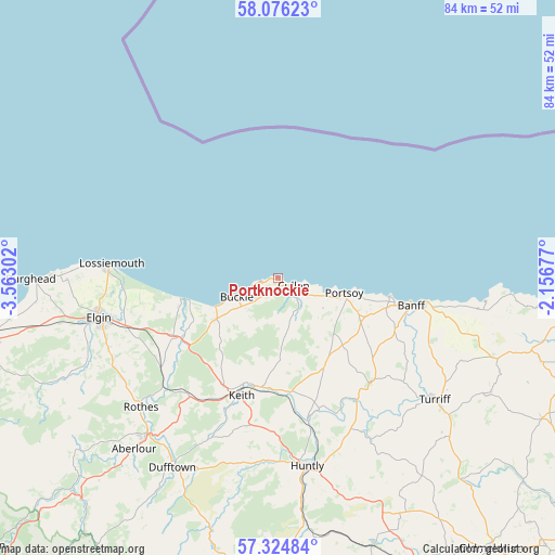
Portknockie GPS coordinates[2]
57° 42' 8.928" North, 2° 51' 35.604" West
| Map corner | latitude | longitude |
|---|---|---|
| Upper-left | 58.07623°, | -3.56302° |
| Center: | 57.70248°, | -2.85989° |
| Lower-right: | 57.32484°, | -2.15677° |
| Map W x H: | 83.5×83.5 km | = 51.9×51.9mi |
| max Lat: | 60.39635° ⇑0.4% North |
| Portknockie: | 57.70248° |
| min Lat: | ⇓99.6% South 34.60088° |
| min Long | Portknockie | max Long |
| -7.64133° | -2.85989° | 32.95536° |
| W 27.8%⇐ | ⇒72.2% E |
Elevation
Elevation of Portknockie is 42 m = 138 ft, and this is 30.9 m = 101 ft below average elevation for this country.
| Max E: |
515 m = 1690 ft | 63.1% |
| Avg. | 72.9 m = 239 ft | |
| Portknockie | 42 m = 138 ft | |
Min E: |
-30 m = -98 ft | 36.9% |
See also: United Kingdom elevation on elevation.city.
Geographical zone
Portknockie is located in North temperate zone (between Tropic of Cancer and the Arctic Circle). Distance of this North polar circle is 985.3 km =612.2 mi to North.| Distance of | km | miles | from Portknockie |
|---|---|---|---|
| North Pole | 3591.1 | 2231.4 | to North |
| Arctic Circle | 985.3 | 612.2 | to North |
| Tropic Cancer | 3810 | 2367.4 | to South |
| Equator | 6415.9 | 3986.7 | to South |


Nearby cities:
15 places around Portknockie: (largest is in red/bold)
• Aberchirder
21 km =13 mi,  138°
138°
• Banff
20.1 km =12.5 mi,  102°
102°
• Buckie
6.8 km =4.2 mi,  243°
243°
• Cullen
2.8 km =1.7 mi,  118°
118°
• Findochty
2.5 km =1.6 mi,  256°
256°
• Fochabers
17.3 km =10.7 mi, 235°
• Garmouth
15.4 km =9.6 mi,  254°
254°
• Keith
19.2 km =11.9 mi,  195°
195°
• Lhanbryde
22.6 km =14 mi, 250°
• Lossiemouth
25.2 km =15.7 mi,  274°
274°
• Macduff
21.9 km =13.6 mi, 99°
• Mosstodloch
17.8 km =11.1 mi, 241°
• Portgordon
10.1 km =6.3 mi, 244°
• Portsoy
10.4 km =6.5 mi, 103°
• Whitehills
16.9 km =10.5 mi, 99°
Sources, notices
• [Note1] Compared only with cities in United Kingdom existing in our database
• [Src1] Map data: © OpenStreetMap contributors (CC-BY-SA)
• [Src2] Other city data from geonames.org with taken over terms of usage.
• [Src3] Geographical zone / Annual Mean Temperature by Robert A. Rohde @ Wikipedia
