Fochabers geodata
Fochabers (Scotland) is a populated place; located in United Kingdom in Europe/London (GMT+0) time zone. With population of 1,690 people, there are 2867 cities with bigger population in this country. Compared to other cities in United Kingdom, 99.1% of cities are located further ↓South; 77% of cities are located further →East and 66.8% of cities have higher elevation than Fochabers. Note1


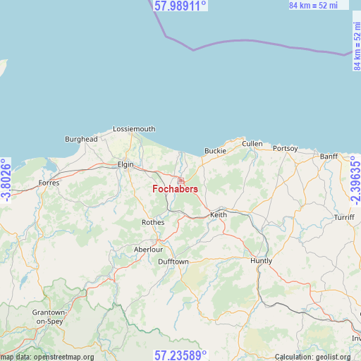
Fochabers GPS coordinates[2]
57° 36' 52.02" North, 3° 5' 58.092" West
| Map corner | latitude | longitude |
|---|---|---|
| Upper-left | 57.98911°, | -3.8026° |
| Center: | 57.61445°, | -3.09947° |
| Lower-right: | 57.23589°, | -2.39635° |
| Map W x H: | 83.8×83.7 km | = 52.1×52mi |
| max Lat: | 60.39635° ⇑0.9% North |
| Fochabers: | 57.61445° |
| min Lat: | ⇓99.1% South 34.60088° |
| min Long | Fochabers | max Long |
| -7.64133° | -3.09947° | 32.95536° |
| W 23%⇐ | ⇒77% E |
Elevation
Elevation of Fochabers is 37 m = 121 ft, and this is 35.9 m = 118 ft below average elevation for this country.
| Max E: |
515 m = 1690 ft | 66.8% |
| Avg. | 72.9 m = 239 ft | |
| Fochabers | 37 m = 121 ft | |
Min E: |
-30 m = -98 ft | 33.2% |
See also: United Kingdom elevation on elevation.city.
Geographical zone
Fochabers is located in North temperate zone (between Tropic of Cancer and the Arctic Circle). Distance of this North polar circle is 995 km =618.3 mi to North.| Distance of | km | miles | from Fochabers |
|---|---|---|---|
| North Pole | 3600.9 | 2237.5 | to North |
| Arctic Circle | 995 | 618.3 | to North |
| Tropic Cancer | 3800.2 | 2361.3 | to South |
| Equator | 6406.1 | 3980.6 | to South |


Nearby cities:
15 places around Fochabers: (largest is in red/bold)
• Buckie
10.6 km =6.6 mi,  50°
50°
• Charlestown of Aberlour
17.6 km =10.9 mi,  205°
205°
• Cullen
18.7 km =11.6 mi,  63°
63°
• Dufftown
18.8 km =11.7 mi,  185°
185°
• Elgin
13.6 km =8.5 mi,  286°
286°
• Findochty
15 km =9.3 mi, 52°
• Garmouth
5.6 km =3.5 mi,  354°
354°
• Hopeman
22.1 km =13.7 mi,  297°
297°
• Keith
12.5 km =7.8 mi,  133°
133°
• Lhanbryde
7.4 km =4.6 mi, 288°
• Lossiemouth
16.2 km =10.1 mi,  317°
317°
• Mosstodloch
1.8 km =1.1 mi,  312°
312°
• Portgordon
7.5 km =4.7 mi,  42°
42°
• Portknockie
17.3 km =10.7 mi, 55°
• Rothes
11.7 km =7.3 mi, 213°
Sources, notices
• [Note1] Compared only with cities in United Kingdom existing in our database
• [Src1] Map data: © OpenStreetMap contributors (CC-BY-SA)
• [Src2] Other city data from geonames.org with taken over terms of usage.
• [Src3] Geographical zone / Annual Mean Temperature by Robert A. Rohde @ Wikipedia
