Omagh geodata
Omagh (Northern Ireland) is a seat of a second-order administrative division; located in United Kingdom in Europe/London (GMT+1) time zone. With population of 21,056 people, there are 556 cities with bigger population in this country. Compared to other cities in United Kingdom, 83.2% of cities are located further ↓South; 99.7% of cities are located further →East and 57.1% of cities have lower elevation than Omagh. Note1


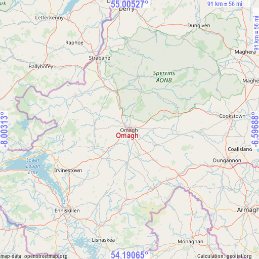
Omagh GPS coordinates[2]
54° 36' 0" North, 7° 18' 0" West
| Map corner | latitude | longitude |
|---|---|---|
| Upper-left | 55.00527°, | -8.00313° |
| Center: | 54.6°, | -7.3° |
| Lower-right: | 54.19065°, | -6.59688° |
| Map W x H: | 90.6×90.6 km | = 56.3×56.3mi |
| max Lat: | 60.39635° ⇑16.8% North |
| Omagh: | 54.6° |
| min Lat: | ⇓83.2% South 34.60088° |
| min Long | Omagh | max Long |
| -7.64133° | -7.3° | 32.95536° |
| W 0.3%⇐ | ⇒99.7% E |
Elevation
Elevation of Omagh is 72 m = 236 ft, and this is 0.90000000000001 m = 3 ft below average elevation for this country.
| Max E: |
515 m = 1690 ft | 42.9% |
| Avg. | 72.9 m = 239 ft | |
| Omagh | 72 m = 236 ft | |
Min E: |
-30 m = -98 ft | 57.1% |
See also: United Kingdom elevation on elevation.city.
Geographical zone
Omagh is located in North temperate zone (between Tropic of Cancer and the Arctic Circle). Distance of this North polar circle is 1330.2 km =826.5 mi to North.| Distance of | km | miles | from Omagh |
|---|---|---|---|
| North Pole | 3936.1 | 2445.8 | to North |
| Arctic Circle | 1330.2 | 826.5 | to North |
| Tropic Cancer | 3465 | 2153.1 | to South |
| Equator | 6071 | 3772.3 | to South |


Nearby cities:
15 places around Omagh: (largest is in red/bold)
• Ballinamallard
28.8 km =17.9 mi,  219°
219°
• Castlederg
22.3 km =13.9 mi,  302°
302°
• Coalisland
39.1 km =24.3 mi,  99°
99°
• Cookstown
36 km =22.4 mi,  82°
82°
• Draperstown
40.9 km =25.4 mi,  57°
57°
• Dromore
14.1 km =8.8 mi,  226°
226°
• Dungannon
36 km =22.4 mi,  107°
107°
• Enniskillen
35.8 km =22.2 mi, 218°
• Fintona
11.2 km =7 mi,  185°
185°
• Fivemiletown
24.1 km =15 mi,  180°
180°
• Irvinestown
26.1 km =16.2 mi,  235°
235°
• Lisnaskea
40.1 km =24.9 mi, 193°
• Newtownstewart
14 km =8.7 mi,  338°
338°
• Sion Mills
23.6 km =14.7 mi,  331°
331°
• Strabane
27.1 km =16.8 mi, 336°
Sources, notices
• [Note1] Compared only with cities in United Kingdom existing in our database
• [Src1] Map data: © OpenStreetMap contributors (CC-BY-SA)
• [Src2] Other city data from geonames.org with taken over terms of usage.
• [Src3] Geographical zone / Annual Mean Temperature by Robert A. Rohde @ Wikipedia
