Newtownstewart geodata
Newtownstewart (Northern Ireland) is a populated place; located in United Kingdom in Europe/London (GMT+1) time zone. With population of 1,465 people, there are 3076 cities with bigger population in this country. Compared to other cities in United Kingdom, 84.4% of cities are located further ↓South; 99.8% of cities are located further →East and 55.1% of cities have higher elevation than Newtownstewart. Note1


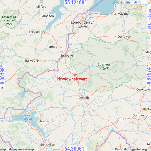
Newtownstewart GPS coordinates[2]
54° 43' 4.008" North, 7° 22' 43.896" West
| Map corner | latitude | longitude |
|---|---|---|
| Upper-left | 55.12188°, | -8.08199° |
| Center: | 54.71778°, | -7.37886° |
| Lower-right: | 54.30961°, | -6.67574° |
| Map W x H: | 90.3×90.3 km | = 56.1×56.1mi |
| max Lat: | 60.39635° ⇑15.6% North |
| Newtownstewart: | 54.71778° |
| min Lat: | ⇓84.4% South 34.60088° |
| min Long | Newtownstewart | max Long |
| -7.64133° | -7.37886° | 32.95536° |
| W 0.2%⇐ | ⇒99.8% E |
Elevation
Elevation of Newtownstewart is 53 m = 174 ft, and this is 19.9 m = 65 ft below average elevation for this country.
| Max E: |
515 m = 1690 ft | 55.1% |
| Avg. | 72.9 m = 239 ft | |
| Newtownstewart | 53 m = 174 ft | |
Min E: |
-30 m = -98 ft | 44.9% |
See also: United Kingdom elevation on elevation.city.
Geographical zone
Newtownstewart is located in North temperate zone (between Tropic of Cancer and the Arctic Circle). Distance of this North polar circle is 1317.1 km =818.4 mi to North.| Distance of | km | miles | from Newtownstewart |
|---|---|---|---|
| North Pole | 3923 | 2437.6 | to North |
| Arctic Circle | 1317.1 | 818.4 | to North |
| Tropic Cancer | 3478.1 | 2161.2 | to South |
| Equator | 6084 | 3780.4 | to South |


Nearby cities:
15 places around Newtownstewart: (largest is in red/bold)
• Ballinamallard
37.7 km =23.4 mi,  200°
200°
• Castlederg
13.8 km =8.6 mi,  265°
265°
• Culmore
37.6 km =23.4 mi,  10°
10°
• Derry
31.5 km =19.6 mi, 8°
• Draperstown
40.3 km =25 mi,  76°
76°
• Dromore
23.3 km =14.5 mi,  192°
192°
• Dungiven
38.1 km =23.7 mi,  51°
51°
• Eglinton
35.5 km =22.1 mi,  20°
20°
• Fintona
24.5 km =15.2 mi,  170°
170°
• Fivemiletown
37.5 km =23.3 mi, 172°
• Irvinestown
32.4 km =20.1 mi,  210°
210°
• Londonderry County Borough
31.4 km =19.5 mi, 8°
• Omagh
14 km =8.7 mi,  158°
158°
• Sion Mills
9.8 km =6.1 mi,  322°
322°
• Strabane
13.1 km =8.1 mi,  333°
333°
Sources, notices
• [Note1] Compared only with cities in United Kingdom existing in our database
• [Src1] Map data: © OpenStreetMap contributors (CC-BY-SA)
• [Src2] Other city data from geonames.org with taken over terms of usage.
• [Src3] Geographical zone / Annual Mean Temperature by Robert A. Rohde @ Wikipedia
