Oldham geodata
Oldham (England) is a seat of a second-order administrative division; located in United Kingdom in Europe/London (GMT+0) time zone. With population of 104,782 people, there are 91 cities with bigger population in this country. Compared to other cities in United Kingdom, 70.6% of cities are located further ↓South; 57.2% of cities are located further →East and 96.8% of cities have lower elevation than Oldham. Note1


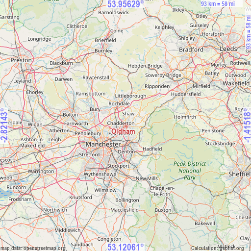
Oldham GPS coordinates[2]
53° 32' 25.836" North, 2° 7' 5.88" West
| Map corner | latitude | longitude |
|---|---|---|
| Upper-left | 53.95629°, | -2.82143° |
| Center: | 53.54051°, | -2.1183° |
| Lower-right: | 53.12061°, | -1.41518° |
| Map W x H: | 92.9×92.9 km | = 57.7×57.7mi |
| max Lat: | 60.39635° ⇑29.4% North |
| Oldham: | 53.54051° |
| min Lat: | ⇓70.6% South 34.60088° |
| min Long | Oldham | max Long |
| -7.64133° | -2.1183° | 32.95536° |
| W 42.8%⇐ | ⇒57.2% E |
Elevation
Elevation of Oldham is 204 m = 669 ft, and this is 131.1 m = 430 ft above average elevation for this country.
| Max E: |
515 m = 1690 ft | 3.2% |
| Oldham | 204 m 669 ft | |
| Avg. | 72.9 m = 239 ft | |
Min E: |
-30 m = -98 ft | 96.8% |
See also: Oldham elevation on elevation.city.
Geographical zone
Oldham is located in North temperate zone (between Tropic of Cancer and the Arctic Circle). Distance of this North polar circle is 1448 km =899.7 mi to North.| Distance of | km | miles | from Oldham |
|---|---|---|---|
| North Pole | 4053.9 | 2519 | to North |
| Arctic Circle | 1448 | 899.7 | to North |
| Tropic Cancer | 3347.2 | 2079.9 | to South |
| Equator | 5953.1 | 3699.1 | to South |


Nearby cities:
15 places around Oldham: (largest is in red/bold)
• Ashton-under-Lyne
5.9 km =3.7 mi,  167°
167°
• Blackley
6.8 km =4.2 mi,  248°
248°
• Crumpsall
8.7 km =5.4 mi, 253°
• Delph
7.3 km =4.5 mi,  66°
66°
• Diggle
8.5 km =5.3 mi, 69°
• Droylsden
7 km =4.3 mi,  194°
194°
• Dukinfield
7.6 km =4.7 mi,  164°
164°
• Failsworth
5.1 km =3.2 mi,  218°
218°
• Heywood
8.8 km =5.5 mi,  310°
310°
• Middleton
5.5 km =3.4 mi,  281°
281°
• Milnrow
7.9 km =4.9 mi,  2°
2°
• Mossley
6.2 km =3.9 mi,  117°
117°
• Royton
2.7 km =1.7 mi,  353°
353°
• Shaw
3.7 km =2.3 mi,  38°
38°
• Stalybridge
7.4 km =4.6 mi,  148°
148°
Sources, notices
• [Note1] Compared only with cities in United Kingdom existing in our database
• [Src1] Map data: © OpenStreetMap contributors (CC-BY-SA)
• [Src2] Other city data from geonames.org with taken over terms of usage.
• [Src3] Geographical zone / Annual Mean Temperature by Robert A. Rohde @ Wikipedia
