Middleton geodata
Middleton (England) is a populated place; located in United Kingdom in Europe/London (GMT+1) time zone. With population of 45,589 people, there are 261 cities with bigger population in this country. Compared to other cities in United Kingdom, 70.8% of cities are located further ↓South; 59.2% of cities are located further →East and 65.3% of cities have lower elevation than Middleton. Note1


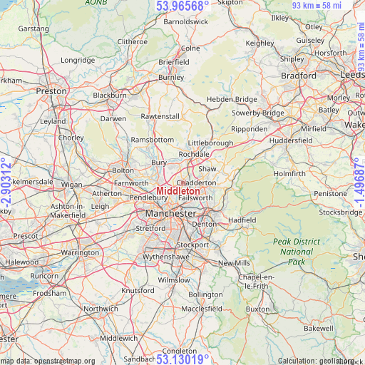
Middleton GPS coordinates[2]
53° 33' 0" North, 2° 12' 0" West
| Map corner | latitude | longitude |
|---|---|---|
| Upper-left | 53.96568°, | -2.90312° |
| Center: | 53.55°, | -2.2° |
| Lower-right: | 53.13019°, | -1.49687° |
| Map W x H: | 92.9×92.9 km | = 57.7×57.7mi |
| max Lat: | 60.39635° ⇑29.2% North |
| Middleton: | 53.55° |
| min Lat: | ⇓70.8% South 34.60088° |
| min Long | Middleton | max Long |
| -7.64133° | -2.2° | 32.95536° |
| W 40.8%⇐ | ⇒59.2% E |
Elevation
Elevation of Middleton is 87 m = 285 ft, and this is 14.1 m = 46 ft above average elevation for this country.
| Max E: |
515 m = 1690 ft | 34.7% |
| Middleton | 87 m 285 ft | |
| Avg. | 72.9 m = 239 ft | |
Min E: |
-30 m = -98 ft | 65.3% |
See also: Middleton elevation on elevation.city.
Geographical zone
Middleton is located in North temperate zone (between Tropic of Cancer and the Arctic Circle). Distance of this North polar circle is 1447 km =899.1 mi to North.| Distance of | km | miles | from Middleton |
|---|---|---|---|
| North Pole | 4052.9 | 2518.4 | to North |
| Arctic Circle | 1447 | 899.1 | to North |
| Tropic Cancer | 3348.3 | 2080.5 | to South |
| Equator | 5954.2 | 3699.8 | to South |


Nearby cities:
15 places around Middleton: (largest is in red/bold)
• Blackley
3.7 km =2.3 mi,  194°
194°
• Cheetham Hill
6.3 km =3.9 mi,  203°
203°
• Crumpsall
4.6 km =2.9 mi,  219°
219°
• Droylsden
8.6 km =5.3 mi,  155°
155°
• Failsworth
5.5 km =3.4 mi, 155°
• Heywood
4.9 km =3 mi,  344°
344°
• Manchester
8.1 km =5 mi, 197°
• Oldham
5.5 km =3.4 mi,  101°
101°
• Prestwich
5.8 km =3.6 mi,  251°
251°
• Radcliffe
8.3 km =5.2 mi,  279°
279°
• Rochdale
8.1 km =5 mi,  21°
21°
• Royton
5.4 km =3.4 mi,  71°
71°
• Shaw
7.9 km =4.9 mi,  76°
76°
• Simister
3.6 km =2.2 mi,  268°
268°
• Whitefield
6.6 km =4.1 mi, 270°
Sources, notices
• [Note1] Compared only with cities in United Kingdom existing in our database
• [Src1] Map data: © OpenStreetMap contributors (CC-BY-SA)
• [Src2] Other city data from geonames.org with taken over terms of usage.
• [Src3] Geographical zone / Annual Mean Temperature by Robert A. Rohde @ Wikipedia
