Newton-le-Willows geodata
Newton-le-Willows (England) is a populated place; located in United Kingdom in Europe/London (GMT+1) time zone. With population of 21,782 people, there are 544 cities with bigger population in this country. Compared to other cities in United Kingdom, 68.8% of cities are located further ↓South; 67.1% of cities are located further →East and 68.3% of cities have higher elevation than Newton-le-Willows. Note1


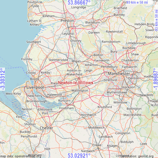
Newton-le-Willows GPS coordinates[2]
53° 27' 0" North, 2° 36' 0" West
| Map corner | latitude | longitude |
|---|---|---|
| Upper-left | 53.86667°, | -3.30312° |
| Center: | 53.45°, | -2.6° |
| Lower-right: | 53.02921°, | -1.89687° |
| Map W x H: | 93.1×93.1 km | = 57.8×57.8mi |
| max Lat: | 60.39635° ⇑31.2% North |
| Newton-le-Willows: | 53.45° |
| min Lat: | ⇓68.8% South 34.60088° |
| min Long | Newton-le-Willo | max Long |
| -7.64133° | -2.6° | 32.95536° |
| W 32.9%⇐ | ⇒67.1% E |
Elevation
Elevation of Newton-le-Willows is 35 m = 115 ft, and this is 37.9 m = 124 ft below average elevation for this country.
| Max E: |
515 m = 1690 ft | 68.3% |
| Avg. | 72.9 m = 239 ft | |
| Newton-le-Willows | 35 m = 115 ft | |
Min E: |
-30 m = -98 ft | 31.7% |
See also: United Kingdom elevation on elevation.city.
Geographical zone
Newton-le-Willows is located in North temperate zone (between Tropic of Cancer and the Arctic Circle). Distance of this North polar circle is 1458.1 km =906 mi to North.| Distance of | km | miles | from Newton-le-Willows |
|---|---|---|---|
| North Pole | 4064 | 2525.3 | to North |
| Arctic Circle | 1458.1 | 906 | to North |
| Tropic Cancer | 3337.2 | 2073.6 | to South |
| Equator | 5943.1 | 3692.9 | to South |


Nearby cities:
15 places around Newton-le-Willows: (largest is in red/bold)
• Abram
6.5 km =4 mi,  4°
4°
• Ashton in Makerfield
5 km =3.1 mi,  318°
318°
• Bickershaw
7.4 km =4.6 mi,  15°
15°
• Billinge
8.9 km =5.5 mi,  306°
306°
• Burtonwood
4.5 km =2.8 mi,  239°
239°
• Croft
3.8 km =2.4 mi,  119°
119°
• Culcheth
5.2 km =3.2 mi,  88°
88°
• Glazebury
7.1 km =4.4 mi,  71°
71°
• Golborne
3 km =1.9 mi, 4°
• Great Sankey
6.9 km =4.3 mi,  202°
202°
• Haydock
5.7 km =3.5 mi,  289°
289°
• Leigh
7.4 km =4.6 mi,  45°
45°
• St Helens
8.8 km =5.5 mi,  270°
270°
• Warrington
6.5 km =4 mi,  168°
168°
• Winwick
1.9 km =1.2 mi,  180°
180°
Sources, notices
• [Note1] Compared only with cities in United Kingdom existing in our database
• [Src1] Map data: © OpenStreetMap contributors (CC-BY-SA)
• [Src2] Other city data from geonames.org with taken over terms of usage.
• [Src3] Geographical zone / Annual Mean Temperature by Robert A. Rohde @ Wikipedia
